IMAGES TAKEN NEAR TO
Benagh Road, NEWRY, BT34 4SJ
Introduction
This page details the photographs taken nearby to Benagh Road, BT34 4SJ by members of the Geograph project.
The Geograph project started in 2005 with the aim of publishing, organising and preserving representative images for every square kilometre of Great Britain, Ireland and the Isle of Man.

There are currently over 7.5m images from over14,400 individuals and you can help contribute to the project by visiting https://www.geograph.org.uk
Image Map
Images are licensed for reuse under creativecommons.org/licenses/by-sa/2.0
Notes
- Clicking on the map will re-center to the selected point.
- The higher the marker number, the further away the image location is from the centre of the postcode.
Image Listing (13 Images Found)
Images are licensed for reuse under creativecommons.org/licenses/by-sa/2.0
Image
Details
Distance
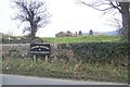
1
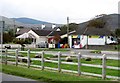
Eileen's Store on the Benagh Road
Situated next a public picnic site, Eileen's store faces Mill Bay.
Image: © Eric Jones
Taken: 19 Oct 2012
0.05 miles
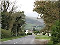
2
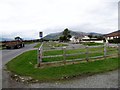
Picnic and parking site on the Benagh Road
This site overlooks Mill Bay.
Image: © Eric Jones
Taken: 19 Oct 2012
0.07 miles
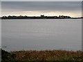
3
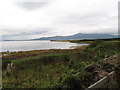
The shores of Mill Bay viewed from the Benagh Road
The Cooley Mountains of the Irish Republic form the background.
Image: © Eric Jones
Taken: 19 Oct 2012
0.07 miles
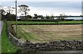
4
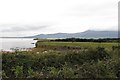
Grazings on the shores of Mill Bay
The grazings are protected by a sea wall.
Image: © Eric Jones
Taken: 19 Oct 2012
0.09 miles
5
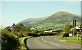
The Benagh Road near Kilkeel
A minor road, through flat countryside, close to Carlingford Lough (behind the hedge on the left). There is a convenient picnic site on the right The Mournes are in the background.
Image: © Albert Bridge
Taken: 20 Sep 2008
0.11 miles
7
The old cemetery at Lisnacree viewed from the A2
Mill Bay forms the background
Image: © Eric Jones
Taken: 19 Oct 2012
0.19 miles
8
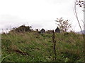
The wilderness of Lisnacree graveyard
There was a medieval church on this site, which was destroyed in the uprising of 1621.
Image: © Eric Jones
Taken: 19 Oct 2012
0.19 miles
9
Lisnacree Graveyard
This is in the townland of Lisnacree, in the Parish et Kilkeel, on the road from Rostrevor to Greencastle, It contains the site of a church founded by St Thuan in the time of St Patrick, but It was ruined even In 1622 There are only 5 stones, the oldest dating from 1781.
Image: © HENRY CLARK
Taken: 3 Jan 2009
0.19 miles
10
Mill Bay from the Benagh Road
The outline of Greencastle's medieval fortress Image can be seen in the background.
Image: © Eric Jones
Taken: 19 Oct 2012
0.21 miles