IMAGES TAKEN NEAR TO
Tullyframe Road, NEWRY, BT34 4SA
Introduction
This page details the photographs taken nearby to Tullyframe Road, BT34 4SA by members of the Geograph project.
The Geograph project started in 2005 with the aim of publishing, organising and preserving representative images for every square kilometre of Great Britain, Ireland and the Isle of Man.

There are currently over 7.5m images from over14,400 individuals and you can help contribute to the project by visiting https://www.geograph.org.uk
Image Map
Images are licensed for reuse under creativecommons.org/licenses/by-sa/2.0
Notes
- Clicking on the map will re-center to the selected point.
- The higher the marker number, the further away the image location is from the centre of the postcode.
Image Listing (36 Images Found)
Images are licensed for reuse under creativecommons.org/licenses/by-sa/2.0
Image
Details
Distance
1
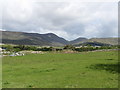
Grazing land on the western outskirts of Atticall village
The highest peak in the background is Eagle Mountain.
Image: © Eric Jones
Taken: 28 May 2011
0.10 miles
2
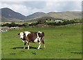
How Now Brown Cow?
A cow on land next to the construction site of a residential estate. The col in the background between Eagle Mountain and Slievemoughanmore is known as the Windy Gap.
Image: © Eric Jones
Taken: 28 May 2011
0.11 miles
5
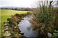
The White Water River below Ballymageogh Bridge
Image: © Eric Jones
Taken: 28 May 2011
0.14 miles
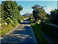
6
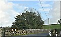
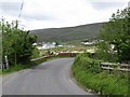
Tullyframe Road approaching Ballymagough Bridge west of Atticall
Image: © Eric Jones
Taken: 7 Jul 2017
0.14 miles
7
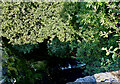
Yellow Water at Island Road bridge, Tullyframe
This is a tributary of the White Water river.
Image: © Eric Jones
Taken: 25 Aug 2021
0.14 miles
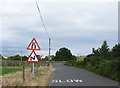
8
View North along Island Road from the bridge over the Yellow Water
Slieve Muck towers in the background.
Image: © Eric Jones
Taken: 25 Aug 2021
0.14 miles
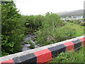
9
The Tullyframe Road at Ballymageogh Bridge
The bridge, west of the village of Atticall, spans the White Water River. The colours are those of the Down GAA.
Image: © Eric Jones
Taken: 28 May 2011
0.15 miles
10
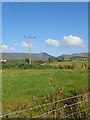
11kV power lines in the White Water valley
The image was taken from Island Road.
Image: © Eric Jones
Taken: 25 Aug 2021
0.15 miles