IMAGES TAKEN NEAR TO
Head Road, NEWRY, BT34 4RL
Introduction
This page details the photographs taken nearby to Head Road, BT34 4RL by members of the Geograph project.
The Geograph project started in 2005 with the aim of publishing, organising and preserving representative images for every square kilometre of Great Britain, Ireland and the Isle of Man.

There are currently over 7.5m images from over14,400 individuals and you can help contribute to the project by visiting https://www.geograph.org.uk
Image Map
Images are licensed for reuse under creativecommons.org/licenses/by-sa/2.0
Notes
- Clicking on the map will re-center to the selected point.
- The higher the marker number, the further away the image location is from the centre of the postcode.
Image Listing (37 Images Found)
Images are licensed for reuse under creativecommons.org/licenses/by-sa/2.0
Image
Details
Distance
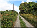
1
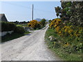
The Rourke's Park Track
This untarred road leading to Annalong Forest links a number of dwellings with the Head Road which runs along the southern flank of the Mourne Mountains.
Image: © Eric Jones
Taken: 29 Apr 2011
0.05 miles
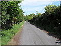
2
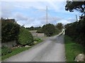
Southern end of the Dunnywater Track
The Dunnywater Track links with the Head Road.
Image: © Eric Jones
Taken: 27 Sep 2015
0.05 miles
3
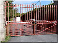
Gates to the Northern Ireland Water's estate at Annalong Wood
The incident tape on the gate was place there by the NIFRS while tackling the Mourne's worst wild fires in living memory.
Image: © Eric Jones
Taken: 4 May 2011
0.09 miles
4
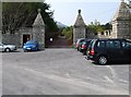
The gate into Annalong Woods
Walkers and pedal cyclists are welcome to use the well made road which leads through the forest to the reservoir weir.
Image: © Eric Jones
Taken: 29 Apr 2011
0.09 miles
5
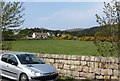
Dressed stone wall boundary of the estate of Northern Ireland Water
This contrasts with the "single" stone wall on nearby land. Image
Image: © Eric Jones
Taken: 29 Apr 2011
0.09 miles
9
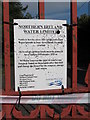
Notice to farmers concerning grazing rights in the Annalong Valley
This notice, peppered by shots, is attached to the estate gates. Large areas of grazing land were destroyed in the recent fires.
Image: © Eric Jones
Taken: 4 May 2011
0.10 miles
10
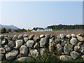
An Ulster "Single" Stone Wall on the Head Road
These walls built of large stones appear odd to Welsh eyes familiar with the 'Double' style of the Welsh "clawdd mynydd" (mountain wall) built with two outer layers separated by an infilling of smaller stones.
Image: © Eric Jones
Taken: 29 Apr 2011
0.10 miles