IMAGES TAKEN NEAR TO
Main Road, NEWRY, BT34 4NY
Introduction
This page details the photographs taken nearby to Main Road, BT34 4NY by members of the Geograph project.
The Geograph project started in 2005 with the aim of publishing, organising and preserving representative images for every square kilometre of Great Britain, Ireland and the Isle of Man.

There are currently over 7.5m images from over14,400 individuals and you can help contribute to the project by visiting https://www.geograph.org.uk
Image Map
Images are licensed for reuse under creativecommons.org/licenses/by-sa/2.0
Notes
- Clicking on the map will re-center to the selected point.
- The higher the marker number, the further away the image location is from the centre of the postcode.
Image Listing (35 Images Found)
Images are licensed for reuse under creativecommons.org/licenses/by-sa/2.0
Image
Details
Distance
1
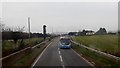
A "Not In Service" Ulster Bus on the Newcastle Road
Image: © Eric Jones
Taken: 16 Feb 2018
0.05 miles
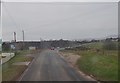
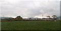
2
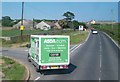
The A2 approaching the Pat's Road junction outside Ballymartin
Pat's Road which links the A2 with the sea plays a pivotal role in the social and cultural life of the village and the nearby town of Kilkeel. The Ballymartin GAA club which draws its members and supporters from the Nationalist community is located on this road and on "The Twelfth" Orangemen from the Kingdom of Mourne march some 5km from Kilkeel to Pat's Road and back again.
Image: © Eric Jones
Taken: 16 Feb 2018
0.08 miles
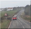
3
Pat's Road junction on the A2
This is located between the village of Ballymartin and the fishing port of Kilkeel.
Image: © Eric Jones
Taken: 16 Feb 2018
0.08 miles
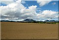
4
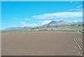
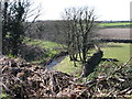
Arable land between Kilkeel and Ballymartin
The Mournes form the background. The post prominent mountain in this view is the iconic Slieve Binnian.
Image: © Eric Jones
Taken: 2 May 2016
0.09 miles
5
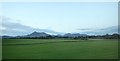
Flat farmland North of the A2(Newcastle Road)
The High Mournes, including Binnian and Slieve Donard, can be seen in the background.
Image: © Eric Jones
Taken: 24 Sep 2018
0.10 miles
6
Cottages in the Ballykeel Road area
These are on the western outskirts of the village of Ballymartin. The Mournes form the background.
Image: © Eric Jones
Taken: 11 May 2010
0.11 miles
7
Potato fields on the north side of Newcastle Road
These are located between Kilkeel and Ballymartin. The Mournes provide a spectacular background.
Image: © Eric Jones
Taken: 28 May 2015
0.11 miles
8
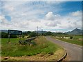
Anthonys Road with the Mournes in the background
Image: © Eric Jones
Taken: 12 Jul 2012
0.11 miles
10
The A2 at the junction with Anthony's Road near Ballymartin
Image: © Eric Jones
Taken: 1 Jul 2014
0.11 miles