IMAGES TAKEN NEAR TO
Wrack Road, NEWRY, BT34 4NT
Introduction
This page details the photographs taken nearby to Wrack Road, BT34 4NT by members of the Geograph project.
The Geograph project started in 2005 with the aim of publishing, organising and preserving representative images for every square kilometre of Great Britain, Ireland and the Isle of Man.

There are currently over 7.5m images from over14,400 individuals and you can help contribute to the project by visiting https://www.geograph.org.uk
Image Map
Images are licensed for reuse under creativecommons.org/licenses/by-sa/2.0
Notes
- Clicking on the map will re-center to the selected point.
- The higher the marker number, the further away the image location is from the centre of the postcode.
Image Listing (15 Images Found)
Images are licensed for reuse under creativecommons.org/licenses/by-sa/2.0
Image
Details
Distance
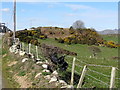
2
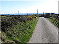
View south along Wrack Road
The name recalls the old Mourne practice of harvesting seaweed or wrack to fertilize the land.
Image: © Eric Jones
Taken: 18 Mar 2011
0.06 miles
3
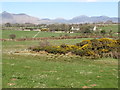
View north-eastwards across the entrenched lower reaches of the Mullagh River
The Mournes form the background.
Image: © Eric Jones
Taken: 18 Mar 2011
0.09 miles
4
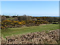
View east from Wrack Road across the Mullagh valley
A drop in sea level led the rejuvenated Mullagh to cut deep into the surface of the newly emergent land. The valley sides are steep and of little use for farming. Most are covered by whins. The netting in the background is at the Cois na Fhairaige GAA club.
Image]
Image: © Eric Jones
Taken: 18 Mar 2011
0.09 miles
5
Wrack Road climbing over a hill just south of the junction with the A2
Image: © Eric Jones
Taken: 18 Mar 2011
0.14 miles
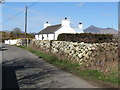
6
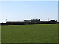
Farmhouse and out buildings on the west side of Wrack Road
Image: © Eric Jones
Taken: 18 Mar 2011
0.14 miles
7
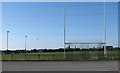
The pitch at Cois na Fhairaige GAA Club, Pats Road
Image: © Eric Jones
Taken: 18 Mar 2011
0.15 miles
8
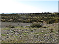
Disused sand and gravel pit on Pats Road
Image: © Eric Jones
Taken: 18 Mar 2011
0.18 miles
9
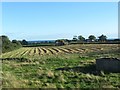
Hay making on the former site of RAF Kilkeel
RAF Kilkeel was a WWII Home Chain Radar Station.
Image: © Eric Jones
Taken: 22 Sep 2015
0.19 miles
10
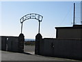
The main gate of Cois na Fhairaige GAA Ground, Pats Road
Image: © Eric Jones
Taken: 18 Mar 2011
0.19 miles