IMAGES TAKEN NEAR TO
Ameracam Lane, NEWRY, BT34 4LN
Introduction
This page details the photographs taken nearby to Ameracam Lane, BT34 4LN by members of the Geograph project.
The Geograph project started in 2005 with the aim of publishing, organising and preserving representative images for every square kilometre of Great Britain, Ireland and the Isle of Man.

There are currently over 7.5m images from over14,400 individuals and you can help contribute to the project by visiting https://www.geograph.org.uk
Image Map
Images are licensed for reuse under creativecommons.org/licenses/by-sa/2.0
Notes
- Clicking on the map will re-center to the selected point.
- The higher the marker number, the further away the image location is from the centre of the postcode.
Image Listing (19 Images Found)
Images are licensed for reuse under creativecommons.org/licenses/by-sa/2.0
Image
Details
Distance
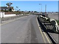
1
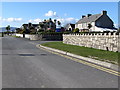
Ameracam Lane near the entrance to the Ameracam Loughside Holiday Park
Image: © Eric Jones
Taken: 28 Feb 2011
0.02 miles
2
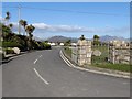
Entrance into the Ameracam Loughside Holiday Park
Image: © Eric Jones
Taken: 28 Feb 2011
0.03 miles
3
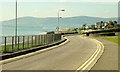
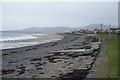
Ameracam Lane, Cranfield
See Image Ameracam Lane (cul-de-sac) runs along the shore beside Cranfield beach. The car park, toilets and (seasonal) lifeguard are out of picture to the right. This can be a busy spot during July and August.
Image: © Albert Bridge
Taken: 20 Sep 2008
0.03 miles
4
Cranfield Bay
The two bounding reefs are Charley's Rock and Cranfield Point Rocks.
Image: © Eric Jones
Taken: 15 Sep 2012
0.04 miles
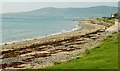
5
Cranfield shoreline
Looking towards Greencastle
Image: © HENRY CLARK
Taken: 17 Jan 2009
0.05 miles
6
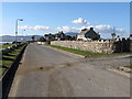
Ameracam Lane, Cranfield West
This lane runs along the sea front. The name Ameracam, has no connection with the nearby WWII American airbase. It is merely a corruption of the Irish name Iomaire Cam meaning "crooked tract of land".
Image: © Eric Jones
Taken: 28 Feb 2011
0.05 miles
7
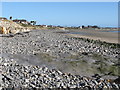
Shingle beach near Soldier's Point, Cranfield West
Image: © Eric Jones
Taken: 28 Feb 2011
0.07 miles
8
Walkers on the beach between Charleys Rock and Soldiers Point
Image: © Eric Jones
Taken: 28 Feb 2011
0.07 miles
9
View eastwards along Ameracam Lane, Cranfield West
Image: © Eric Jones
Taken: 28 Feb 2011
0.08 miles
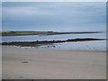
10
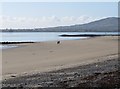
The shore at Cranfield near Kilkeel
Cranfield beach is a blue-flag beach, mostly covered at high water (as shown), to the south west of Kilkeel. The Cooleys, in Co Louth, on the other side of Carlingford Lough, are in the background.
Image: © Albert Bridge
Taken: 20 Sep 2008
0.10 miles