IMAGES TAKEN NEAR TO
Scrogg Road, NEWRY, BT34 4JH
Introduction
This page details the photographs taken nearby to Scrogg Road, BT34 4JH by members of the Geograph project.
The Geograph project started in 2005 with the aim of publishing, organising and preserving representative images for every square kilometre of Great Britain, Ireland and the Isle of Man.

There are currently over 7.5m images from over14,400 individuals and you can help contribute to the project by visiting https://www.geograph.org.uk
Image Map
Images are licensed for reuse under creativecommons.org/licenses/by-sa/2.0
Notes
- Clicking on the map will re-center to the selected point.
- The higher the marker number, the further away the image location is from the centre of the postcode.
Image Listing (14 Images Found)
Images are licensed for reuse under creativecommons.org/licenses/by-sa/2.0
Image
Details
Distance
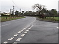
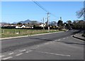
1
The southern end of Sprogg Road
Sprogg Road links the Newry and Greencastle Roads.
Image: © Eric Jones
Taken: 19 Feb 2011
0.02 miles
2
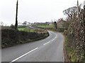
The Greencastle Road west of the junction with Sprogg Road
The Greencastle Road is a dangerous road to walk. It is narrow and twisty, with many blind bends and a substantial volume of fast moving traffic.
Image: © Eric Jones
Taken: 19 Feb 2011
0.09 miles
3
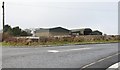
A WWII relic near Kitty's Road
This is the sole survivor of a number of buildings in this one of the dispersed units of Greencastle airfield.
Image: © Eric Jones
Taken: 19 Feb 2011
0.11 miles
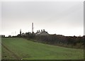
4
The junction of Kitty's Road and the Greencastle Road
The outskirts of Kilkeel can be seen in the background.
Image: © Eric Jones
Taken: 19 Feb 2011
0.13 miles
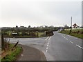
5
The junction of Kitty's Road and the Greencastle Road
This view is taken from Kitty's Road.
Image: © Eric Jones
Taken: 28 Feb 2011
0.13 miles
6
The entrance into Kitty's Road
Kitty's Road is one of a number of roads linking the coast with the Greencastle Road.
Image: © Eric Jones
Taken: 20 Feb 2011
0.13 miles
7
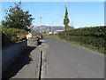
The north-western end of Kitty's Road
The junction with the Greencastle Road can be seen in the background.
Image: © Eric Jones
Taken: 28 Feb 2011
0.15 miles
8
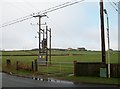
Power lines and farmland on the outskirts of Kilkeel
Image: © Eric Jones
Taken: 20 Feb 2011
0.15 miles
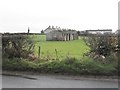
10
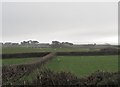
Hedged fields east of the Greencastle Road
The soils in this area are very sandy and lack stones for wall building. Traditionally. hedges have been used to form field boundaries. Ruined buildings from the days of RAF (later USAAF) Greencastle can be seen in the background right.
Image: © Eric Jones
Taken: 19 Feb 2011
0.16 miles