IMAGES TAKEN NEAR TO
Aughnahoory Road, NEWRY, BT34 4HF
Introduction
This page details the photographs taken nearby to Aughnahoory Road, BT34 4HF by members of the Geograph project.
The Geograph project started in 2005 with the aim of publishing, organising and preserving representative images for every square kilometre of Great Britain, Ireland and the Isle of Man.

There are currently over 7.5m images from over14,400 individuals and you can help contribute to the project by visiting https://www.geograph.org.uk
Image Map
Images are licensed for reuse under creativecommons.org/licenses/by-sa/2.0
Notes
- Clicking on the map will re-center to the selected point.
- The higher the marker number, the further away the image location is from the centre of the postcode.
Image Listing (14 Images Found)
Images are licensed for reuse under creativecommons.org/licenses/by-sa/2.0
Image
Details
Distance
1
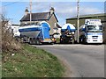
RRS Transport Depot on the Aughnahoory Road
Image: © Eric Jones
Taken: 19 Mar 2011
0.04 miles
2
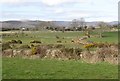
Pastureland west of the Aughnahoory Road
This is an area of small stone wall enclosed fields.
Image: © Eric Jones
Taken: 19 Mar 2011
0.11 miles
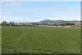
3
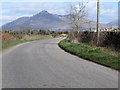
A road bend with a view of Slieve Binnian
The Aughnahoory Road runs northwards from the coastal town of Kilkeel in the direction of the Mourne Mountains. Binnian and its side-kick, Wee Binnian, are the conical hills in the background centre.
Image: © Eric Jones
Taken: 19 Mar 2011
0.15 miles
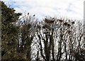
5
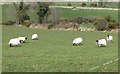
Mourne Blackface Sheep beside the Aughnahoory Road
Image: © Eric Jones
Taken: 19 Mar 2011
0.19 miles
6
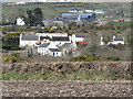
The Hanna Close Clachan from the Carrigenagh Road
Image: © Eric Jones
Taken: 18 Mar 2011
0.19 miles
7
Hanna's Close from Carrigenagh Road
The farms beyond the close are on Aughnahoory Road.
Image: © Eric Jones
Taken: 18 Mar 2011
0.21 miles
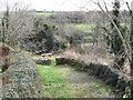
8
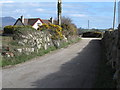
The lane to Hanna's Close clachan
This lane which serves the clachan also continues northwards to the Ballinran Road. It is one of a handful of such narrow lanes officially designated for walkers in the Mourne area. Public footpaths as they exist in England and Wales are absent from most of Ireland and even those which exist are not generally way marked.
Image: © Eric Jones
Taken: 19 Mar 2011
0.22 miles
9
Path leading down to a ford on the Kilkeel River
Hanna's Court has a number of paths and nature trails for visitors.
Image: © Eric Jones
Taken: 19 Mar 2011
0.23 miles
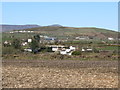
10
Farmland west of the Aughnahoory Road
Aughrim and Knockchree hills can be seen in the middle distance.
Image: © Eric Jones
Taken: 19 Mar 2011
0.23 miles