IMAGES TAKEN NEAR TO
Granite Mews, NEWRY, BT34 4FX
Introduction
This page details the photographs taken nearby to Granite Mews, BT34 4FX by members of the Geograph project.
The Geograph project started in 2005 with the aim of publishing, organising and preserving representative images for every square kilometre of Great Britain, Ireland and the Isle of Man.

There are currently over 7.5m images from over14,400 individuals and you can help contribute to the project by visiting https://www.geograph.org.uk
Image Map
Images are licensed for reuse under creativecommons.org/licenses/by-sa/2.0
Notes
- Clicking on the map will re-center to the selected point.
- The higher the marker number, the further away the image location is from the centre of the postcode.
Image Listing (150 Images Found)
Images are licensed for reuse under creativecommons.org/licenses/by-sa/2.0
Image
Details
Distance
1
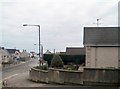
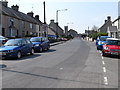
Main Street, Annalong
Main Street is located off the A2 linking it with the port area.
Image: © Eric Jones
Taken: 30 Jan 2011
0.01 miles
2
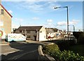
Main Street, Annalong
Main Street extends eastwards from the A2 to the shoreline.
Image: © Eric Jones
Taken: 3 Nov 2012
0.02 miles
3
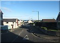
Main Street, Annalong
This links the A2 with the harbour.
Image: © Eric Jones
Taken: 22 Sep 2015
0.03 miles
4
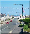
Main Street, Annalong
Main Street leads from the A2 down towards the harbour. The flags and bunting are characteristic of the Loyalist areas of Northern Ireland in the days approaching the Twelfth of July.
http://cain.ulst.ac.uk/images/symbols/flags.htm
Image: © Eric Jones
Taken: 1 Jul 2014
0.04 miles
5
The northern end of Main Street, Annalong
In the background, on the A2, is Annalong Presbyterian Church.
Image: © Eric Jones
Taken: 30 Apr 2011
0.04 miles
6

The coastal village of Annalong from the Head Road
Image: © Eric Jones
Taken: 24 Aug 2016
0.05 miles
7
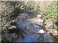
The deeply entrenched Annalong River above the mill bridge
Image: © Eric Jones
Taken: 16 Mar 2011
0.05 miles
8
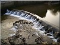
Annalong River (1)
This is the upper weir as the river passes the Harbour and into the Irish Sea.
Image: © P Flannagan
Taken: 9 Feb 2008
0.05 miles
9
Main Street, Annalong
The red, white and blue painted kerb stones is a remainder that Annalong is in ethos a predominantly Loyalist village. The 2011 Census recorded that 52.69% of the population belonged to or were brought up in a Protestant religion compared with 43% in the Catholic religion.
Image: © Eric Jones
Taken: 16 Oct 2019
0.05 miles
10
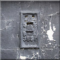
Flush Bracket, Annalong
Flush bracket bench mark on the southern side of a house on the corner of main Street and the A2 Glasdrumman Road in Annalong Image
The number on the bracket is OSBM 3557.
The mark has been levelled to 17.92 metres above MSL.
Image: © Rossographer
Taken: 25 Mar 2018
0.05 miles