IMAGES TAKEN NEAR TO
Rosses Quay, NEWRY, BT34 3GL
Introduction
This page details the photographs taken nearby to Rosses Quay, BT34 3GL by members of the Geograph project.
The Geograph project started in 2005 with the aim of publishing, organising and preserving representative images for every square kilometre of Great Britain, Ireland and the Isle of Man.

There are currently over 7.5m images from over14,400 individuals and you can help contribute to the project by visiting https://www.geograph.org.uk
Image Map
Images are licensed for reuse under creativecommons.org/licenses/by-sa/2.0
Notes
- Clicking on the map will re-center to the selected point.
- The higher the marker number, the further away the image location is from the centre of the postcode.
Image Listing (80 Images Found)
Images are licensed for reuse under creativecommons.org/licenses/by-sa/2.0
Image
Details
Distance
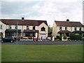
2
Apartments on Warrenpoint Road, Rostrevor
Image: © Eric Jones
Taken: 25 May 2010
0.05 miles
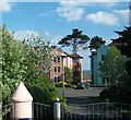
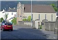
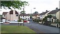
4
St Colman's Gardens, Rostrevor
These houses are situated off Warrenpoint Road.
Image: © Eric Jones
Taken: 11 May 2010
0.07 miles
5
The Rostrevor Presbyterian Church
According to the 2001 Census some 6.1% of Rostrevor's population were Protestants.
Image: © Eric Jones
Taken: 9 Sep 2011
0.08 miles
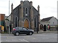
6
The Presbyterian Church, Rostrevor
This is located on Warrenpoint Road.
Image: © Eric Jones
Taken: 14 May 2019
0.08 miles
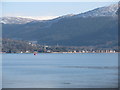
7
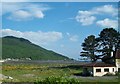
Possible development land west of the Rosses Quay Estate
Most of the land between the A2 and the sea has now been developed with new housing estates and apartment blocks.
Image: © Eric Jones
Taken: 25 May 2010
0.09 miles
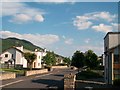
10
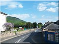
Shore Road
This provides a by-pass which avoids the centre of the village of Rostrevor.
Image: © Eric Jones
Taken: 25 May 2010
0.10 miles