IMAGES TAKEN NEAR TO
Gleann Ruairi, NEWRY, BT34 3GE
Introduction
This page details the photographs taken nearby to Gleann Ruairi, BT34 3GE by members of the Geograph project.
The Geograph project started in 2005 with the aim of publishing, organising and preserving representative images for every square kilometre of Great Britain, Ireland and the Isle of Man.

There are currently over 7.5m images from over14,400 individuals and you can help contribute to the project by visiting https://www.geograph.org.uk
Image Map
Images are licensed for reuse under creativecommons.org/licenses/by-sa/2.0
Notes
- Clicking on the map will re-center to the selected point.
- The higher the marker number, the further away the image location is from the centre of the postcode.
Image Listing (23 Images Found)
Images are licensed for reuse under creativecommons.org/licenses/by-sa/2.0
Image
Details
Distance
7
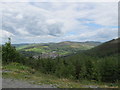
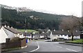
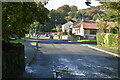
The upper section of the village of Rostrevor from the Cloughmore ridge
Upper Rostrevor occupies the slopes of the valley of the Kilbroney River and is enclosed by the hills of the Western Mournes.
Image: © Eric Jones
Taken: 4 Jun 2012
0.10 miles
8
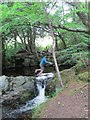
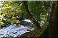
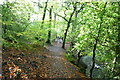
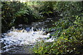
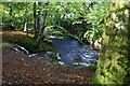
A disaster narrowly avoided at Fairy Glen
Image: © Eric Jones
Taken: 4 Jun 2012
0.12 miles