IMAGES TAKEN NEAR TO
Cloughmore Road, NEWRY, BT34 3EN
Introduction
This page details the photographs taken nearby to Cloughmore Road, BT34 3EN by members of the Geograph project.
The Geograph project started in 2005 with the aim of publishing, organising and preserving representative images for every square kilometre of Great Britain, Ireland and the Isle of Man.

There are currently over 7.5m images from over14,400 individuals and you can help contribute to the project by visiting https://www.geograph.org.uk
Image Map
Images are licensed for reuse under creativecommons.org/licenses/by-sa/2.0
Notes
- Clicking on the map will re-center to the selected point.
- The higher the marker number, the further away the image location is from the centre of the postcode.
Image Listing (55 Images Found)
Images are licensed for reuse under creativecommons.org/licenses/by-sa/2.0
Image
Details
Distance
1
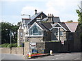
House with a view at the junction of Shore Road and Cloughmore Road, Rostrevor
This house has a fine and uninterrupted view down the Carlingford Lough
Image: © Eric Jones
Taken: 1 Jul 2014
0.01 miles
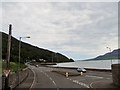
3
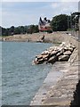
Rock armour protecting Shore Road, Rostrevor
In January 2014 Shore Road and its westward continuation, Warrenpoint Road, were flooded by the sea and the sea wall breached at a number of points. The video on the link provides an idea of the seriousness of the flooding.
http://www.bbc.co.uk/news/uk-northern-ireland-25604156
Image: © Eric Jones
Taken: 1 Jul 2014
0.04 miles
4
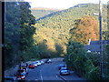
Water Street, Rostrevor
Kilbroney Park and Slievemeen form the background.
Image: © Eric Jones
Taken: 24 Sep 2018
0.04 miles
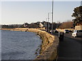
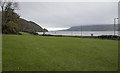
6
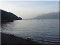
The junction of Bridge Street and Shore Road, Rostrevor
The Carlingford Lough, a deep fjord, bordered by the Western Mournes on the left and the Cooley Mountains on the right, form the background.
Image: © Eric Jones
Taken: 4 Jun 2012
0.06 miles
7
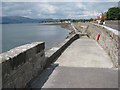
Sea wall at Rostrevor
Warrenpoint Image can be seen at the head of Carlingford Lough. The hills to the left are the Cooley Mountains in County Louth, Irish Republic.
Image: © Oliver Dixon
Taken: 12 May 2007
0.08 miles
8
Kilbroney Park, Rostrevor
Kilbroney Park in Rostrevor near Carlingford Lough.
Image: © Rossographer
Taken: 30 Oct 2015
0.10 miles
10
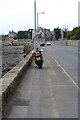
Shore Rd, Rostrevor
Suzie taking a well earned break
Image: © Wilson Adams
Taken: 14 Jul 2003
0.11 miles