IMAGES TAKEN NEAR TO
Killowen Road, NEWRY, BT34 3AQ
Introduction
This page details the photographs taken nearby to Killowen Road, BT34 3AQ by members of the Geograph project.
The Geograph project started in 2005 with the aim of publishing, organising and preserving representative images for every square kilometre of Great Britain, Ireland and the Isle of Man.

There are currently over 7.5m images from over14,400 individuals and you can help contribute to the project by visiting https://www.geograph.org.uk
Image Map
Images are licensed for reuse under creativecommons.org/licenses/by-sa/2.0
Notes
- Clicking on the map will re-center to the selected point.
- The higher the marker number, the further away the image location is from the centre of the postcode.
Image Listing (15 Images Found)
Images are licensed for reuse under creativecommons.org/licenses/by-sa/2.0
Image
Details
Distance
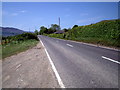
2
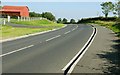
A narrowing section of the Killowen Road (A2) near Ballintur
Image: © Eric Jones
Taken: 4 Jun 2012
0.07 miles
3

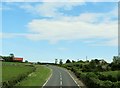
Bungalows below the south-western slopes of Knockshee
Image: © Eric Jones
Taken: 17 Jun 2014
0.07 miles

6
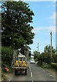
Crawling traffic on a narrow section of the A2
Image: © Eric Jones
Taken: 4 Jun 2012
0.12 miles
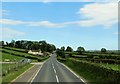
7
The Killowen Road near Rostrevor
The Killowen Road is part of a fairly twisty and narrow main road from Kilkeel to Warrenpoint. The view is towards Kilkeel to the east of Killowen and Ballyedmond.
Image: © Albert Bridge
Taken: 20 Sep 2008
0.14 miles
8
Curve on the Killowen Road (A2) west of Ballintur
Image: © Eric Jones
Taken: 4 Jun 2012
0.15 miles
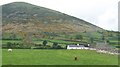
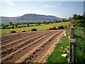
10

Traditional farmhouse and cottage between the A2 and Knockshee
Image: © Eric Jones
Taken: 17 Jun 2014
0.16 miles