IMAGES TAKEN NEAR TO
Ballyvally Road, NEWRY, BT34 2RU
Introduction
This page details the photographs taken nearby to Ballyvally Road, BT34 2RU by members of the Geograph project.
The Geograph project started in 2005 with the aim of publishing, organising and preserving representative images for every square kilometre of Great Britain, Ireland and the Isle of Man.

There are currently over 7.5m images from over14,400 individuals and you can help contribute to the project by visiting https://www.geograph.org.uk
Image Map
Images are licensed for reuse under creativecommons.org/licenses/by-sa/2.0
Notes
- Clicking on the map will re-center to the selected point.
- The higher the marker number, the further away the image location is from the centre of the postcode.
Image Listing (5 Images Found)
Images are licensed for reuse under creativecommons.org/licenses/by-sa/2.0
Image
Details
Distance
1
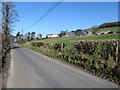
Dairy Farm in the upper Moygannon Valley
The farm stands to the south of the Ballyvally gap and overlooks the Ballyvally Road.
Image: © Eric Jones
Taken: 19 Feb 2013
0.03 miles
2
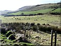
The western slopes of the Ballyvally gap
Ballyvally is derived from the Irish "Baile an bhealaigh" meaning "townland of the pass". This is an area of low grade agricultural land, suitable only for the grazing of sheep and store cattle.
Image: © Eric Jones
Taken: 19 Feb 2013
0.11 miles
3
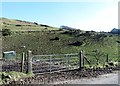
Sheep grazings on the lower slope of Ballyvally Mountain
This image was taken from Ballyvally Road
Image: © Eric Jones
Taken: 19 Feb 2013
0.17 miles
4
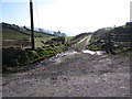
The northern end of Yellow Road
This section of the Yellow Road, here pictured from Mayo Road, now appears to be a private farm track.
Image: © Eric Jones
Taken: 19 Feb 2013
0.22 miles
5
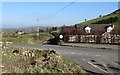
Cross roads on the Ballyvally Road
The image was taken from Mayo Road across Ballyvally Road to the mouth of Edentrumly Road.
Image: © Eric Jones
Taken: 19 Feb 2013
0.24 miles