IMAGES TAKEN NEAR TO
Ballyvally Road, NEWRY, BT34 2RT
Introduction
This page details the photographs taken nearby to Ballyvally Road, BT34 2RT by members of the Geograph project.
The Geograph project started in 2005 with the aim of publishing, organising and preserving representative images for every square kilometre of Great Britain, Ireland and the Isle of Man.

There are currently over 7.5m images from over14,400 individuals and you can help contribute to the project by visiting https://www.geograph.org.uk
Image Map
Images are licensed for reuse under creativecommons.org/licenses/by-sa/2.0
Notes
- Clicking on the map will re-center to the selected point.
- The higher the marker number, the further away the image location is from the centre of the postcode.
Image Listing (7 Images Found)
Images are licensed for reuse under creativecommons.org/licenses/by-sa/2.0
Image
Details
Distance
1
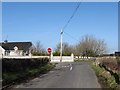
View north towards the Ballyvally Road/Carmeen Road Cross Roads
Image: © Eric Jones
Taken: 19 Feb 2013
0.02 miles
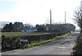
2
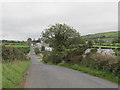
Houses along Carmeen Road
This road, together with Tamnaharry Hill its south-western extension, provides a link between the B8 Newry Road and the B7 Chapel Hill Road.
Image: © Eric Jones
Taken: 14 Sep 2011
0.02 miles
3
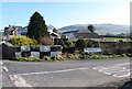
Ballyvally Road at its junction with Carmeen Road
The Carmeen Road bridge is painted in the colours of the local GAA club or, perhaps, -(wishful thinking on my behalf)- the team colours of victorious Swansea City.
http://www.bbc.co.uk/news/uk-wales-14373699
Image: © Eric Jones
Taken: 19 Feb 2013
0.02 miles
4
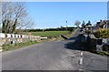
Carmeen Road at its junction with Ballyvally Road
Carnmeen, also the name of the townland, comes from the Irish Ceathranhadh Mhin meaning "the level quarter". Ballyvally is derived from Baile an bhealaigh which means "townland of the gap/pass. Ballyvally Road links Mayobridge and Warrenpoint.
Image: © Eric Jones
Taken: 19 Feb 2013
0.02 miles
5
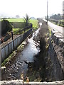
The Clanrye River at the Carmeen Road bridge
Here, the Clanrye flows alongside Ballyvally Road.
Image: © Eric Jones
Taken: 19 Feb 2013
0.05 miles
6
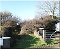
Rath off Ballyvally Road
A rath is a circular enclosure surrounded by an earthen wall. It was used as a dwelling and stronghold in first millennium CE. Folk belief in later times associated them with the wee people and were places to be avoided especially after sun down.
Image: © Eric Jones
Taken: 19 Feb 2013
0.09 miles
7
Entering Ballyvally TD on the Ballyvally Road
Image: © Eric Jones
Taken: 19 Feb 2013
0.22 miles