IMAGES TAKEN NEAR TO
Glenhone Road, NEWRY, BT34 1TT
Introduction
This page details the photographs taken nearby to Glenhone Road, BT34 1TT by members of the Geograph project.
The Geograph project started in 2005 with the aim of publishing, organising and preserving representative images for every square kilometre of Great Britain, Ireland and the Isle of Man.

There are currently over 7.5m images from over14,400 individuals and you can help contribute to the project by visiting https://www.geograph.org.uk
Image Map
Images are licensed for reuse under creativecommons.org/licenses/by-sa/2.0
Notes
- Clicking on the map will re-center to the selected point.
- The higher the marker number, the further away the image location is from the centre of the postcode.
Image Listing (9 Images Found)
Images are licensed for reuse under creativecommons.org/licenses/by-sa/2.0
Image
Details
Distance
1
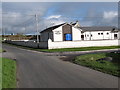
Ardaragh Free Presbyterian Church
This church is strategically located at the cross roads of the Ardaragh and Glenhone Roads. The denomination which dates from 1951 is a breakaway from mainstream Presbyterianism and had as its founder and long time moderator the Rev Dr Ian Kyle Paisley (now Baron Bannside)
Image: © Eric Jones
Taken: 27 Oct 2011
0.13 miles
2
Approaching the Ardaragh Free Presbyterian Church
This view northwards is taken from the Ardaragh Road.
Image: © Eric Jones
Taken: 24 Mar 2012
0.13 miles
3
Houses on the Ardaragh Road
The image was taken from A25 (Newry Road).
Image: © Eric Jones
Taken: 14 Mar 2017
0.14 miles
4
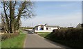
Cross roads by the Ardaragh Free Presbyterian Church
These are very quiet back-roads.
Image: © Eric Jones
Taken: 24 Mar 2012
0.14 miles
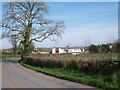
5
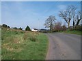
Farmhouse and Buildings on the Ardaragh Road
Image: © Eric Jones
Taken: 24 Mar 2012
0.15 miles
6
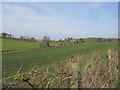
Farmland near the Ardaragh Free Presbyterian Church
Image: © Eric Jones
Taken: 24 Mar 2012
0.18 miles
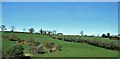
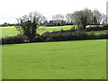
7
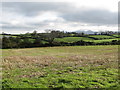
Farmland east of Ardaragh Road
This is very much drumlin country. The Mournes form the background.
Image: © Eric Jones
Taken: 27 Oct 2011
0.19 miles
8
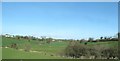
Valley between the Ardaragh Road and Glenhorne Road
The two road running northwards from the A25 (Newry Road) run along dry-site drumlin ridges. The stream occupying the valley is one of the headwaters of the Clanrye River.
Image: © Eric Jones
Taken: 14 Mar 2017
0.21 miles
9
Disused farm buildings west of Drumgreenagh Road
Image: © Eric Jones
Taken: 27 Oct 2011
0.23 miles