IMAGES TAKEN NEAR TO
Carrickrovaddy Road, NEWRY, BT34 1SN
Introduction
This page details the photographs taken nearby to Carrickrovaddy Road, BT34 1SN by members of the Geograph project.
The Geograph project started in 2005 with the aim of publishing, organising and preserving representative images for every square kilometre of Great Britain, Ireland and the Isle of Man.

There are currently over 7.5m images from over14,400 individuals and you can help contribute to the project by visiting https://www.geograph.org.uk
Image Map
Images are licensed for reuse under creativecommons.org/licenses/by-sa/2.0
Notes
- Clicking on the map will re-center to the selected point.
- The higher the marker number, the further away the image location is from the centre of the postcode.
Image Listing (7 Images Found)
Images are licensed for reuse under creativecommons.org/licenses/by-sa/2.0
Image
Details
Distance
1
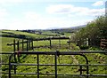
Cattlefold on the south side of Carrickrovaddy Road
This is set in a drumlin landscape.
Image: © Eric Jones
Taken: 10 Apr 2019
0.03 miles
2
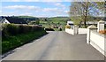
Ribbon settlement along the Carrickrovaddy Road
Image: © Eric Jones
Taken: 10 Apr 2019
0.05 miles
3
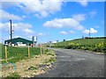
New intensive farming unit on Carrickrovaddy Road
This unit is absent from the Google Maps.
Image: © Eric Jones
Taken: 10 Apr 2019
0.07 miles
4
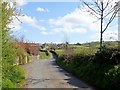
The Carrickrovaddy Road east of Jarrettspass
Barr Hill is seen in the background right.
Image: © Eric Jones
Taken: 10 Apr 2019
0.07 miles
5
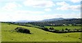
The Newry Valley extending southwards towards the head of Carlingford Lough
The glacially modified valley was used for the construction of the Newry Canal. In the background are the mountains of the Ring of Gullion and the mountains of the Cooley Peninsula. This image was taken East of Jerrettspass.
Image: © Eric Jones
Taken: 10 Apr 2019
0.22 miles
6
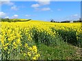
Oilseed rape crop on the north side of the Carrickrovaddy Road
Image: © Eric Jones
Taken: 10 Apr 2019
0.23 miles
7
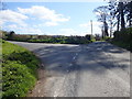
Junction in Carrickrovaddy Road East of Jerrettspass
Both stretches of road are known as Carrickrovaddy Road.
Image: © Eric Jones
Taken: 10 Apr 2019
0.24 miles