IMAGES TAKEN NEAR TO
Belfast Road, NEWRY, BT34 1QT
Introduction
This page details the photographs taken nearby to Belfast Road, BT34 1QT by members of the Geograph project.
The Geograph project started in 2005 with the aim of publishing, organising and preserving representative images for every square kilometre of Great Britain, Ireland and the Isle of Man.

There are currently over 7.5m images from over14,400 individuals and you can help contribute to the project by visiting https://www.geograph.org.uk
Image Map
Images are licensed for reuse under creativecommons.org/licenses/by-sa/2.0
Notes
- Clicking on the map will re-center to the selected point.
- The higher the marker number, the further away the image location is from the centre of the postcode.
Image Listing (13 Images Found)
Images are licensed for reuse under creativecommons.org/licenses/by-sa/2.0
Image
Details
Distance
1
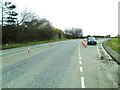
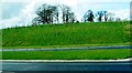
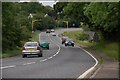
The former A1 road at Sheepbridge (2)
Here the old A1 Belfast-Dublin road (now bypassed on a high quality dual carriageway to the right of the camera) briefly became a dual carriageway (known as the Tinker Hill section) as it approached the Newry from the north.
The northbound two lanes began to merge into one roughly where my car is parked.
Image: © Dean Molyneaux
Taken: 5 Apr 2010
0.03 miles
2
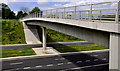
The new Newry bypass (22)
See Image A new flyover across the site of the new bypass, to the south of the Sheep Bridge Image Continue to Image Image shows the completed version.
Image: © Albert Bridge
Taken: 27 Jul 2008
0.10 miles
3
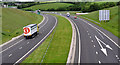
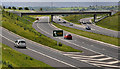
The Newry bypass (2)
The view, towards Banbridge and Belfast, from this flyover Image just north of the Sheep Bridge junction. The off-slip for Newry and Warrenpoint traffic is on the right.
Image: © Albert Bridge
Taken: 30 May 2011
0.10 miles
4
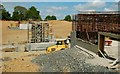
The Newry bypass (1)
A flyover carrying a farm lane across the bypass near the Sheep Bridge junction. Image shows it under construction, in July 2008.
Image: © Albert Bridge
Taken: 30 May 2011
0.13 miles
5
The A1 north-east of the Sheepsbridge Roundabout
Image: © Eric Jones
Taken: 2 Apr 2011
0.15 miles
6
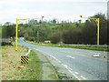
The former A1 road at Sheepbridge (1)
Looking peaceful now that the traffic has been routed onto the new A1 Belfast-Dublin dual carriageway (opened October 2009). It presently serves as an access road from the 'Sheepbridge' exit on the new A1 to the Sheepbridge Restaurant complex and the Corcreechy Road.
The average speed cameras (SPECS) - which were only installed in late 2006 - are most likely redundant now given the quietness of this road. That said, I wouldn't chance racing through the bend ahead at 70mph to find out!
Townland of Carnmeen.
Image: © Dean Molyneaux
Taken: 5 Apr 2010
0.19 miles
7
The Newry bypass (3)
The Sheep Bridge junction (looking towards Newry and Dublin) seen from this flyover Image The old Belfast Road into Newry Image, including the Tinker Hill dual carriageway section Image, which was numbered as the A1 (Belfast to the Border) has been re-numbered as the A28 ie as part of the Newry – Armagh road.
Image: © Albert Bridge
Taken: 30 May 2011
0.20 miles
8
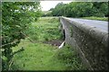
The Sheep Bridge near Newry
The Sheep Bridge carries the Belfast – Dublin road across the Newry River to the north of Newry. The view is towards Belfast.
Note added 23 October 2009. The bridge is no longer part of the Belfast – Dublin road ending around 160 years of road history. For an explanation, see Image and Image
Image: © Albert Bridge
Taken: 17 Jun 2007
0.21 miles
9
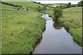
The Newry River at the Sheep Bridge
See Image This is the Newry River, looking downstream, from the bridge.
Image: © Albert Bridge
Taken: 17 Jun 2007
0.21 miles
10
The Belfast - Dublin road near the Sheep Bridge
The Belfast – Dublin road, near the Sheep Bridge Image looking towards Newry/Dublin and the start of the Tinker Hill dual carriageway. This twisting stretch of single carriageway is to be replaced Image
Image: © Albert Bridge
Taken: 17 Jun 2007
0.21 miles