IMAGES TAKEN NEAR TO
Lawnfield Grove, NEWCASTLE, BT33 0US
Introduction
This page details the photographs taken nearby to Lawnfield Grove, BT33 0US by members of the Geograph project.
The Geograph project started in 2005 with the aim of publishing, organising and preserving representative images for every square kilometre of Great Britain, Ireland and the Isle of Man.

There are currently over 7.5m images from over14,400 individuals and you can help contribute to the project by visiting https://www.geograph.org.uk
Image Map
Images are licensed for reuse under creativecommons.org/licenses/by-sa/2.0
Notes
- Clicking on the map will re-center to the selected point.
- The higher the marker number, the further away the image location is from the centre of the postcode.
Image Listing (386 Images Found)
Images are licensed for reuse under creativecommons.org/licenses/by-sa/2.0
Image
Details
Distance
1
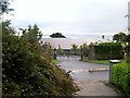
The Shimna Integrated College, Newcastle
This is a non-sectarian school.
http://www.shimnacollege.org.uk/
Image
Image: © Eric Jones
Taken: 11 Sep 2010
0.02 miles
2
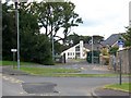
Shimna Integrated College, King Street
In a society where education has traditionally been organised on strictly sectarian lines, the integrated school movement - in the face of fierce opposition from the vested religious interests - has sought to break down barriers by educating children from both religious communities. There are at present 56 grant-aided integrated schools in Northern Ireland with a total enrolment of over 17000 pupils – some 5 percent of total pupils.
http://www.nicie.org
http://www.shimnacollege.org.uk/
Image: © Eric Jones
Taken: 21 Aug 2009
0.03 miles
3
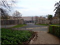
All Children's Integrated Primary School, Newcastle
This is located next to the Shimna Integrated College.
Image: © Eric Jones
Taken: 24 Mar 2020
0.05 miles
4
The Primary School attached to Shimna Integrated College
Image: © Eric Jones
Taken: 8 Apr 2012
0.05 miles
5
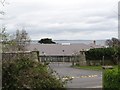
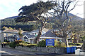
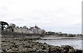
The core of Victorian Newcastle
The oldest part of the town of Newcastle lies between the Lower Glen valley and the Drineever ridge of the Mournes. The spire is that of St John's CoI Church.
Image: © Eric Jones
Taken: 3 Jan 2019
0.06 miles
6
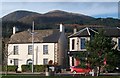
A Georgian house on the Central Promenade
Slieve Commedagh and Shan Slieve mountains form the background.
Image: © Eric Jones
Taken: 8 Nov 2010
0.06 miles
7
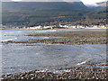
View south towards the Mournes across shingle lobes
Image: © Eric Jones
Taken: 26 Feb 2012
0.07 miles
8
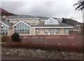
Glenada YMCA Conference Centre, South Promenade, Newcastle
Image: © Eric Jones
Taken: 28 Apr 2021
0.07 miles
9
Victorian houses on Newcastle's Central Promenade
Image: © Eric Jones
Taken: 13 May 2012
0.07 miles
10
Glenada Holiday and Conference Centre on Newcastle's Central Promenade
Image: © Eric Jones
Taken: 16 Feb 2018
0.08 miles