IMAGES TAKEN NEAR TO
Old Road, NEWCASTLE, BT33 0QQ
Introduction
This page details the photographs taken nearby to Old Road, BT33 0QQ by members of the Geograph project.
The Geograph project started in 2005 with the aim of publishing, organising and preserving representative images for every square kilometre of Great Britain, Ireland and the Isle of Man.

There are currently over 7.5m images from over14,400 individuals and you can help contribute to the project by visiting https://www.geograph.org.uk
Image Map
Images are licensed for reuse under creativecommons.org/licenses/by-sa/2.0
Notes
- Clicking on the map will re-center to the selected point.
- The higher the marker number, the further away the image location is from the centre of the postcode.
Image Listing (33 Images Found)
Images are licensed for reuse under creativecommons.org/licenses/by-sa/2.0
Image
Details
Distance
1
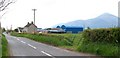
Traditional farm buildings with blue roofs
These blue roofs stand out in the satellite photographs. The blue roofs, the red doors and the white window frames combine to make a political statement.
Image: © Eric Jones
Taken: 13 May 2010
0.00 miles
2
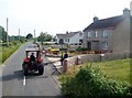
Agricultural traffic on the Old Road between Dundrum and Newcastle
Image: © Eric Jones
Taken: 10 Jul 2015
0.02 miles
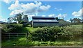
3
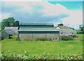
Farm buildings between the Old Road and the A2
Image: © Eric Jones
Taken: 10 Jul 2015
0.08 miles
4
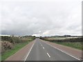
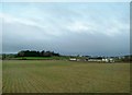
A near empty A2 between the Twelve Arches Bridge and Dundrum
Image: © Eric Jones
Taken: 17 Apr 2017
0.09 miles
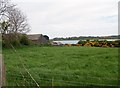
5
Farm house and outbuildings between the A2 (Dundrum Road) and the Old Road
Image: © Eric Jones
Taken: 1 Oct 2020
0.09 miles
6
Farm buildings near the Inner Dundrum Bay
Image: © Eric Jones
Taken: 13 May 2008
0.09 miles
7
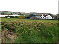
Farm house between Old Road and the A2
The Dundrum Inner Bay and the sand dunes of the Murlough Reserve can be seen in the background, The white van is on the A2.
Image: © Eric Jones
Taken: 13 May 2010
0.09 miles
8
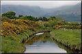
The Carrigs River near Dundrum
The Carrigs River rises as the Leitrim River to the NW of Castlewellan. It is flowing, towards the photographer, into Dundrum Bay. The cloud-capped Mournes can be seen in the background.
Image: © Albert Bridge
Taken: 23 May 2007
0.14 miles
9
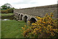
The Twelve Arches near Dundrum
The Twelve Arches carries the old Newcastle – Dundrum/Belfast road across the Carrigs River, to the south of Dundrum. The view is towards Dundrum. One arch is hidden behind the whin bush.
Image: © Albert Bridge
Taken: 23 May 2007
0.14 miles