IMAGES TAKEN NEAR TO
Slievenaman Road, NEWCASTLE, BT33 0QE
Introduction
This page details the photographs taken nearby to Slievenaman Road, BT33 0QE by members of the Geograph project.
The Geograph project started in 2005 with the aim of publishing, organising and preserving representative images for every square kilometre of Great Britain, Ireland and the Isle of Man.

There are currently over 7.5m images from over14,400 individuals and you can help contribute to the project by visiting https://www.geograph.org.uk
Image Map
Images are licensed for reuse under creativecommons.org/licenses/by-sa/2.0
Notes
- Clicking on the map will re-center to the selected point.
- The higher the marker number, the further away the image location is from the centre of the postcode.
Image Listing (20 Images Found)
Images are licensed for reuse under creativecommons.org/licenses/by-sa/2.0
Image
Details
Distance
1
Houses on the south-facing slope of the Shimna Valley
Image: © Eric Jones
Taken: 25 Jul 2014
0.07 miles
2
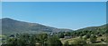
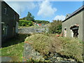
Derelict house on the Slievenaman Road
The image was taken from the B180 (Hilltown Road). The high mountain the background is Slieve Meelmore, the first climb of the day.
Image: © Eric Jones
Taken: 25 Jul 2014
0.10 miles
3
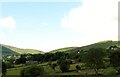
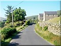
Settlement on the slopes of Slievenaman
The Slievenaman Road, seen in the centre of the photo, links the B180 (Hilltown Road) with the B27 (Kilkeel Road).
Image: © Eric Jones
Taken: 26 Jul 2013
0.10 miles
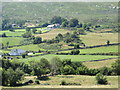
4
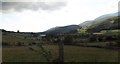
Drumlin belt between the Mournes and the Slieve Croob range
The drumlin dominated landscape was formed by the passage of massive ice sheets during the Quaternary period. The Quaternary Ice Age came to an end some 13,000 years ago revealing a landscape of rounded hills of glacial debris. Isostatic movements led to the rejuvenation of the rivers - including the Shimna in the foreground- which deeply incised themselves into the landscape. The hills in the background are members of the Slieve Croob range.
Image: © Eric Jones
Taken: 22 Jul 2017
0.12 miles
5
A pair of derelict houses on Slievenamon Road
Image: © Eric Jones
Taken: 30 Aug 2024
0.12 miles
7
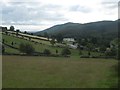
View east down the Shimna Valley from the Slievenaman Road
The forested area beyond is part of the Tollymore Forest Park. The clachan of holiday homes in the centre of the image is known as Millar's Close.
Image
Image: © Eric Jones
Taken: 13 Jun 2013
0.13 miles
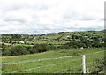
8
Farmland in the upper Shimna Valley
This image is taken from the Slievenaman Road. It shows land sloping down to the Shimna River. The clachan of houses in the background are Millar's Close.
Image]
Image: © Eric Jones
Taken: 26 Jul 2013
0.13 miles
9
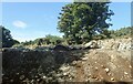
Stone quarry at The Rock above the Slievenaman Road
Image: © Eric Jones
Taken: 25 Aug 2022
0.14 miles
10
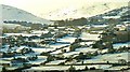
Snow in the Mournes near Bryansford
This view, from the Bryansford – Hilltown road near Tullyree, was typical of Mourne country today.
Image: © Albert Bridge
Taken: 7 Feb 2009
0.14 miles