IMAGES TAKEN NEAR TO
Hilltown Road, NEWCASTLE, BT33 0QA
Introduction
This page details the photographs taken nearby to Hilltown Road, BT33 0QA by members of the Geograph project.
The Geograph project started in 2005 with the aim of publishing, organising and preserving representative images for every square kilometre of Great Britain, Ireland and the Isle of Man.

There are currently over 7.5m images from over14,400 individuals and you can help contribute to the project by visiting https://www.geograph.org.uk
Image Map
Images are licensed for reuse under creativecommons.org/licenses/by-sa/2.0
Notes
- Clicking on the map will re-center to the selected point.
- The higher the marker number, the further away the image location is from the centre of the postcode.
Image Listing (21 Images Found)
Images are licensed for reuse under creativecommons.org/licenses/by-sa/2.0
Image
Details
Distance
1
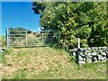
Green lane leading from the B180 to Tullyree Hill
This is not a public right away.
Image: © Eric Jones
Taken: 25 Aug 2022
0.06 miles
2
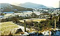
Mournes view near Bryansford
The snow-covered view towards Butter Mountain, from the Bryansford – Hilltown road near Tullyree.
Image: © Albert Bridge
Taken: 7 Feb 2009
0.08 miles
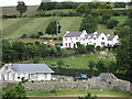
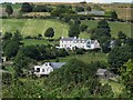
3
Millar's Close Holiday Cottages
This is a clachan of modern holiday cottages built in the traditional Ulster style.
Image: © Eric Jones
Taken: 26 Jul 2013
0.10 miles
5
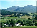
Millar's Court viewed from the B180
The forest in the middle ground is the Clonachuillion Wood, while the peaks in the background are Slieve Bearnagh and Slieve Meelmore.
Image: © Eric Jones
Taken: 25 Jul 2014
0.11 miles
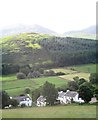
6
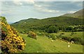
Mourne country near Bryansford (3)
The view from the Bryansford – Hilltown road with Tollymore forest running across the middle of the photo. Continue to Image
Image: © Albert Bridge
Taken: 3 Jun 2008
0.12 miles
7
Millar's Court Holiday Cottages
This is a clachan of modern holiday cottages built in the traditional Ulster style.
Image: © Eric Jones
Taken: 25 Jul 2014
0.13 miles
8
The Hilltown - Bryansford road
The view towards Bryansford with the Irish Sea and Tollymore forest visible in the background.
Image: © Albert Bridge
Taken: 3 Jun 2008
0.17 miles
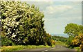
9
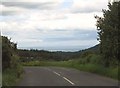
A bend in the B180 at Tullyree
On the horizon, beyond the woodlands of Tollymore Park Forest, can be seen the outline of the Isle of Man.
Image: © Eric Jones
Taken: 30 Jun 2011
0.18 miles
10
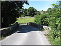
Clonachullion Bridge on the Trassey Road
This bridge, approached on both sides by a blind bend, spans the Shimna River.
Image: © Eric Jones
Taken: 25 Jul 2014
0.18 miles