IMAGES TAKEN NEAR TO
Keel Point, NEWCASTLE, BT33 0NQ
Introduction
This page details the photographs taken nearby to Keel Point, BT33 0NQ by members of the Geograph project.
The Geograph project started in 2005 with the aim of publishing, organising and preserving representative images for every square kilometre of Great Britain, Ireland and the Isle of Man.

There are currently over 7.5m images from over14,400 individuals and you can help contribute to the project by visiting https://www.geograph.org.uk
Image Map
Images are licensed for reuse under creativecommons.org/licenses/by-sa/2.0
Notes
- Clicking on the map will re-center to the selected point.
- The higher the marker number, the further away the image location is from the centre of the postcode.
Image Listing (70 Images Found)
Images are licensed for reuse under creativecommons.org/licenses/by-sa/2.0
Image
Details
Distance
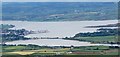
3
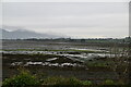
The Mourne Mountains seen across Inner Dundrum Bay
Image: © N Chadwick
Taken: 29 Oct 2021
0.07 miles
5
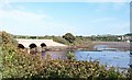
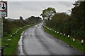
The northern end of the Downshire Bridge
The bridge carries the Keel Point road over the waters of the Carrigs River. St Donard's Church at Dundrum is visible on the extreme right.
Image: © Eric Jones
Taken: 12 Sep 2010
0.09 miles
6
Downshire Bridge from the grounds of Murlough House
Image: © Eric Jones
Taken: 7 Nov 2010
0.10 miles
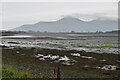
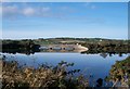
8
Keel Point Causeway and Downshire Bridge crossing Inner Dundrum Bay
The causeway, here seen at high water, connects the Murlough Estate with Dundrum. Murlough House on the estate was built by the Marquesses of Downshire as a summer residence. The causeway and bridge were constructed in the 1850e.
Image: © Eric Jones
Taken: 3 Jun 2015
0.12 miles
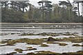
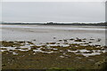
10
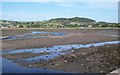
The Estuary of The Carrigs River from the Downshire Bridge
This view was taken at low water. The wooded Shague Hill forms the background.
Image: © Eric Jones
Taken: 12 Sep 2010
0.12 miles