IMAGES TAKEN NEAR TO
Kilkeel Road, NEWCASTLE, BT33 0LB
Introduction
This page details the photographs taken nearby to Kilkeel Road, BT33 0LB by members of the Geograph project.
The Geograph project started in 2005 with the aim of publishing, organising and preserving representative images for every square kilometre of Great Britain, Ireland and the Isle of Man.

There are currently over 7.5m images from over14,400 individuals and you can help contribute to the project by visiting https://www.geograph.org.uk
Image Map
Images are licensed for reuse under creativecommons.org/licenses/by-sa/2.0
Notes
- Clicking on the map will re-center to the selected point.
- The higher the marker number, the further away the image location is from the centre of the postcode.
Image Listing (15 Images Found)
Images are licensed for reuse under creativecommons.org/licenses/by-sa/2.0
Image
Details
Distance
1

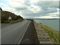
Entering the Kingdom of Mourne on the A2 south of Newcastle
The modernistic house on the right -Scott on the Rocks - won BBC Northern Ireland's "House of the Year Award" in 2011.
http://newcastlerocks.org/2011/01/12/newcastle-home-to-be-house-of-the-year/
Image: © Eric Jones
Taken: 12 Jul 2012
0.04 miles
2
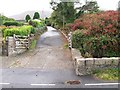
Access lane from the A2 near Maggy's Leap
This lane alongside the Srupatrick stream affords access on foot only to the Donard Forest.
Image: © Eric Jones
Taken: 11 Sep 2010
0.06 miles
3
Entering the Kingdom of Mourne along the A2
The house on the left - Scotts on The Rocks- was named BBC Northern Ireland House of the Year in 2011.
http://www.fjcharleton.com/work/scotts-on-the-rocks.php
Image: © Eric Jones
Taken: 2 May 2016
0.07 miles
4
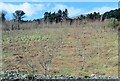
Young deciduous plantation above the A2 at Bealach-beg
Image: © Eric Jones
Taken: 19 Mar 2011
0.08 miles
5
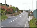
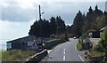
Approaching the boundary between Newry and Mourne District and Down District
At the sign, the coastal road - the A2 - undergoes a name change from Ballagh Road to that of Kilkeel Road. The bridge this side of the sign crosses the Srupatrick stream.
Image: © Eric Jones
Taken: 11 Sep 2010
0.08 miles
6
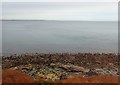
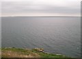
Wavecut platform at Bealach Beag - Ballaghbeg
This image was taken from the A2.
Image: © Eric Jones
Taken: 2 Nov 2018
0.08 miles
7
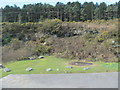
Lay-by and picnic area at Bealach-beg, Newcastle
This is located in an old quarry.
Image: © Eric Jones
Taken: 19 Mar 2011
0.09 miles
8

View downhill to the Ballagh Road (A2) from the Drinneevar Loop
Image: © Eric Jones
Taken: 16 Jul 2015
0.12 miles
9
Bealach Beag - Ballaghbeg , Donards Cove
Bealach Beag - Small passing
looking to Newcastle and Slieve Croob
Image: © Kevin O'Kane
Taken: 28 Dec 2005
0.12 miles