IMAGES TAKEN NEAR TO
Ballagh Road, NEWCASTLE, BT33 0LA
Introduction
This page details the photographs taken nearby to Ballagh Road, BT33 0LA by members of the Geograph project.
The Geograph project started in 2005 with the aim of publishing, organising and preserving representative images for every square kilometre of Great Britain, Ireland and the Isle of Man.

There are currently over 7.5m images from over14,400 individuals and you can help contribute to the project by visiting https://www.geograph.org.uk
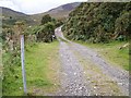
Image Map
Images are licensed for reuse under creativecommons.org/licenses/by-sa/2.0
Notes
- Clicking on the map will re-center to the selected point.
- The higher the marker number, the further away the image location is from the centre of the postcode.
Image Listing (124 Images Found)
Images are licensed for reuse under creativecommons.org/licenses/by-sa/2.0
Image
Details
Distance
1
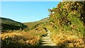
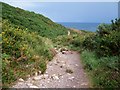
The Brandy Pad near Newcastle (1)
Originally a path used by 18th century smugglers the Brandy Pad is now an official path in the Mournes. This section is close to the start on the Kilkeel Road, near the Bloody Bridge Image See also Image
Image: © Albert Bridge
Taken: 24 Jan 2009
0.03 miles
2
The lower reaches of the Bloody Bridge River
The path on the left is the Brandy Pad.
Image: © Eric Jones
Taken: 11 Sep 2010
0.04 miles
3
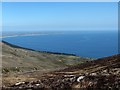
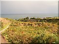
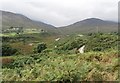
Where the mountains of Mourne sweep down to the sea.
On its northern and southern ends the Mourne Coastal Plain tapers off markedly. North of the Bloody Bridge River the mountains reach the sea. The same is even more true at the southern end between Killowen and Rostrevor.
Image: © Eric Jones
Taken: 20 Apr 2016
0.04 miles
4
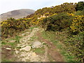
A paved section of the Brandy Pad
Path erosion is a major problem in the Mournes. Even here walkers have created a new path along side the paved area.
Image: © Eric Jones
Taken: 9 Apr 2011
0.05 miles
5
Well developed river terraces in the lower reaches of the Bloody Bridge River valley
As a result of rejuvenation this spate river has carved deep into its former valley floor leaving the remnants as river terraces.
Image: © Eric Jones
Taken: 23 Sep 2014
0.05 miles
6
Access road to cottages at Bloody Bridge
A cottage at the far end of the lane was the home of Professor E.Estyn Evans where he wrote the classic “Mourne Country”. He is quoted as saying: “I only had to lift my eyes to see the hills and watch the coloured seasons climbing from the golden whins to the glowing heather and the snows”.
Image: © Eric Jones
Taken: 9 Apr 2011
0.05 miles
7
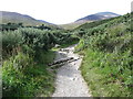
Drainage gully on the Bloody Bridge River path
Surplus water is channelled to the Bloody Bridge River.
Image: © Eric Jones
Taken: 7 Sep 2015
0.06 miles
8
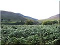
Bracken infestation in the lower Bloody Bridge River valley
Image: © Eric Jones
Taken: 7 Sep 2015
0.06 miles
9
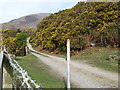
Access track at Bloody Bridge
This track leads to Bloody Bridge Backpackers hostel, barns and camp sites.
http://www.bloodybridge.com/index.html
Image: © Eric Jones
Taken: 11 Sep 2010
0.07 miles
10
The Brandy Pad as it approaches the A2 (Ballagh Road)
Image: © Eric Jones
Taken: 11 Sep 2010
0.07 miles