IMAGES TAKEN NEAR TO
Circular Road, BANBRIDGE, BT32 5LD
Introduction
This page details the photographs taken nearby to Circular Road, BT32 5LD by members of the Geograph project.
The Geograph project started in 2005 with the aim of publishing, organising and preserving representative images for every square kilometre of Great Britain, Ireland and the Isle of Man.

There are currently over 7.5m images from over14,400 individuals and you can help contribute to the project by visiting https://www.geograph.org.uk
Image Map
Images are licensed for reuse under creativecommons.org/licenses/by-sa/2.0
Notes
- Clicking on the map will re-center to the selected point.
- The higher the marker number, the further away the image location is from the centre of the postcode.
Image Listing (3 Images Found)
Images are licensed for reuse under creativecommons.org/licenses/by-sa/2.0
Image
Details
Distance
1
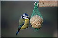
Blue Tit feeding in Tullyorior
This is a close-up of a blue tit feeding in a garden on Circular Road, Tullyorior.
Image: © Michael Wallace
Taken: 13 Dec 2009
0.12 miles
2
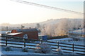
Circular Road, Corbet near Banbridge
This is a view of Circular Road in the townland of Tullyorior near Corbet, Banbridge.
Image: © Michael Wallace
Taken: 25 Dec 2009
0.13 miles
3
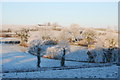
Tullyorior Countryside on Circular Road near Corbet
This is a view of what is known locally as Cappagh Hill and to the right of the picture is old Tullyorior school.
Image: © Michael Wallace
Taken: 25 Dec 2009
0.14 miles