IMAGES TAKEN NEAR TO
Millbank View, BANBRIDGE, BT32 5JL
Introduction
This page details the photographs taken nearby to Millbank View, BT32 5JL by members of the Geograph project.
The Geograph project started in 2005 with the aim of publishing, organising and preserving representative images for every square kilometre of Great Britain, Ireland and the Isle of Man.

There are currently over 7.5m images from over14,400 individuals and you can help contribute to the project by visiting https://www.geograph.org.uk
Image Map
Images are licensed for reuse under creativecommons.org/licenses/by-sa/2.0
Notes
- Clicking on the map will re-center to the selected point.
- The higher the marker number, the further away the image location is from the centre of the postcode.
Image Listing (35 Images Found)
Images are licensed for reuse under creativecommons.org/licenses/by-sa/2.0
Image
Details
Distance
1
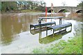
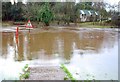
The River Bann in flood (6)
See Image Even the picnic table was not safe. (Note – the Google map is not accurate – see the Multimap instead). For an even higher flood see Image
Image: © Albert Bridge
Taken: 13 Jan 2008
0.01 miles
2
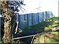
Manmade barrier
Close to the stone bridge at the Drone Hill Road, Tullyconnaught near the Corbet. Looks like its to stop walkers on the land.
Image: © HENRY CLARK
Taken: 27 Dec 2008
0.02 miles
3
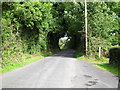
Drone Hill Road at the Bann
The Drone Hill Road at the river level - looking towards the Corbet.
Image: © Dean Molyneaux
Taken: 20 Jul 2009
0.03 miles
4
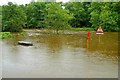
Flood at the Corbet near Banbridge
See Image The Bann had fallen after the last flood in August. Constant rain for almost 24 hours on 5/6 September2008 brought more flooding. This is the Bann (flowing from left to right) at Tullyconnaught, at the Corbet near Banbridge. The picnic table (middle left) can be used as a reference point for a previous flood Image
Image: © Albert Bridge
Taken: 6 Sep 2008
0.03 miles
5
The River Bann in flood (1)
See Image The Bann has broken its banks here after several days of frequent heavy rain and (possibly) the effects of melting snow the previous week. The slipway, in the foreground, is used to launch canoes. (Note – the Google map is not accurate – see the Multimap instead). Image shows the same view after a long dry spell.
Image: © Albert Bridge
Taken: 13 Jan 2008
0.03 miles
6
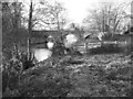
The low Bann at the Corbet
Image showed the Bann at a very high level during flooding. This one shows the Bann looking very low, after a prolonged dry spell during most of May and June, as it flows downstream towards Mulligan’s Bridge
Image: © Albert Bridge
Taken: 26 Jun 2010
0.04 miles
7
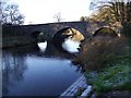
Bridge over the River Bann
Stone bridge at the Drone Hill Road
Image: © HENRY CLARK
Taken: 27 Dec 2008
0.04 miles
8
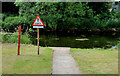
Fire hydrant marker, the Corbet
An old concrete post, from the days of the former Banbridge Rural District Council, marking a section control valve, beside the Bann, at the Drone Hill Road. See also Image
Image: © Albert Bridge
Taken: 26 Jun 2010
0.04 miles
9
Bridge over River Bann
Just off the A50 on the Castlewellan Road
Image: © HENRY CLARK
Taken: 27 Dec 2008
0.04 miles
10
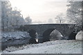
Frost at Mulligan's Bridge, Corbet
This is Mulligan's Bridge at the Corbet on a cold frosty morning.
Image: © Michael Wallace
Taken: 9 Jan 2010
0.05 miles