IMAGES TAKEN NEAR TO
Bronte Road, BANBRIDGE, BT32 5BS
Introduction
This page details the photographs taken nearby to Bronte Road, BT32 5BS by members of the Geograph project.
The Geograph project started in 2005 with the aim of publishing, organising and preserving representative images for every square kilometre of Great Britain, Ireland and the Isle of Man.

There are currently over 7.5m images from over14,400 individuals and you can help contribute to the project by visiting https://www.geograph.org.uk
Image Map
Images are licensed for reuse under creativecommons.org/licenses/by-sa/2.0
Notes
- Clicking on the map will re-center to the selected point.
- The higher the marker number, the further away the image location is from the centre of the postcode.
Image Listing (10 Images Found)
Images are licensed for reuse under creativecommons.org/licenses/by-sa/2.0
Image
Details
Distance
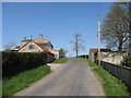
2
Farmhouse and buildings on the Bronte Road
The cottage on the right is the birth place of Alice McClory, the mother of Patrick Bronte.
Image: © Eric Jones
Taken: 28 Mar 2012
0.03 miles
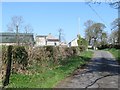
3
Alice McClory's Cottage
This was the childhood home of the mother of Patrick Bronte.
Image: © Eric Jones
Taken: 28 Mar 2012
0.03 miles
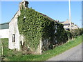
4
Alice McClory's Cottage [2]
This was the childhood home of the mother of Patrick Bronte.
Image: © Eric Jones
Taken: 28 Mar 2012
0.03 miles
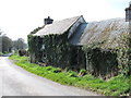
5
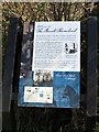
Information board at Alice McClory's Cottage
The Bronte Homeland Drive, a distance of less than 8 miles - in fact, just a wee dander, is well way marked. Much of the route follows country lanes which are generally remarkably free of traffic and are ideal for walking or cycling.
Image: © Eric Jones
Taken: 28 Mar 2012
0.04 miles
6
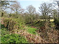
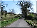
Narrow wooded valley alongside the northern section of Bronte Road
Image: © Eric Jones
Taken: 28 Mar 2012
0.09 miles
7
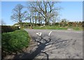
The junction of Bronte Road and Lisnacroppan Road
There is a discrepancy in the spelling between road name signs and the Ordnance Survey Northern Ireland maps. The road signs gives the name as "Lisnacroppin", OSNI prefer "Lisnacroppan".
Image: © Eric Jones
Taken: 28 Mar 2012
0.14 miles
8
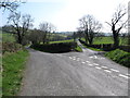
Parting of the ways - the junction of Lisnacroppan and Bronte Roads
Bronte Road is the narrower of the two.
Image: © Eric Jones
Taken: 28 Mar 2012
0.14 miles
10
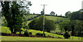
Drumlins near Glascar and Rathfriland
Drumlins are the dominant feature of the landscape between Rathfriland and Glascar. We may guess that the Brunty family would have been familiar with this view, of the southwest Down drumlins, to the north of the Bronte cottage Image Image shows the view familiar to Patrick after his move to Yorkshire.
Image: © Albert Bridge
Taken: 2 Jul 2010
0.21 miles