IMAGES TAKEN NEAR TO
Bramblewood Grove, BANBRIDGE, BT32 4RB
Introduction
This page details the photographs taken nearby to Bramblewood Grove, BT32 4RB by members of the Geograph project.
The Geograph project started in 2005 with the aim of publishing, organising and preserving representative images for every square kilometre of Great Britain, Ireland and the Isle of Man.

There are currently over 7.5m images from over14,400 individuals and you can help contribute to the project by visiting https://www.geograph.org.uk
Image Map
Images are licensed for reuse under creativecommons.org/licenses/by-sa/2.0
Notes
- Clicking on the map will re-center to the selected point.
- The higher the marker number, the further away the image location is from the centre of the postcode.
Image Listing (22 Images Found)
Images are licensed for reuse under creativecommons.org/licenses/by-sa/2.0
Image
Details
Distance
1
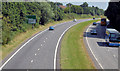
The Banbridge bypass (2013)
The Banbridge bypass, looking towards Dromore and Belfast, from the Castlewellan Road flyover. The 11.30 Belfast (Glengall Street) – Dublin Airport “Aircoach” (middle right) just happened to appear.
Image: © Albert Bridge
Taken: 20 Jul 2013
0.10 miles
2

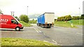
Gap, Banbridge bypass (2)
See Image As he started his right turn, across the dual carriageway, towards Belfast another vehicle turned right from the Newry direction. Both drivers waited for gaps in the passing traffic, were acting sensibly and safely and took no risks but it does illustrate the conflicting movements which, with the wrong driver or a moment of distraction, can be dangerous.
Image: © Albert Bridge
Taken: 19 May 2009
0.14 miles
3
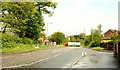
Gap, Banbridge bypass (1)
The Banbridge bypass (in common with most of the road) was built as an all-purpose dual carriageway allowing right and “U” turns. The high number of minor side roads in Co Down means that there are frequent gaps in the central reservation. The road has been improved with two flyovers Image and Image but two gaps remain. One is a minor (and little-used road) while this one (the Old Manse Road Image) leads to an “A” road to Banbridge and Castlewellan Image and is quite busy. See also Image
The driver of this van was waiting patiently for a gap in the traffic before turning right, across the dual carriageway, towards Belfast.
To the best of my knowledge there are no plans to close the gap or replace it with a grade-separated junction.
Image: © Albert Bridge
Taken: 19 May 2009
0.15 miles
4
The Old Manse Road, Banbridge
The Old Manse Road runs from the Castlewellan Road Image to the bypass Image (marked by the passing lorry – background). Now truncated, it was a through road to the Lisnaree Road Image on the Dromore Road. Old Manse Green is on the right.
Image: © Albert Bridge
Taken: 19 May 2009
0.15 miles
5
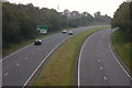
Banbridge bypass, Belfast-Dublin road (4)
See Image This is the road (looking towards Belfast), from the Castlewellan Road bridge, on a Sunday morning.
Image: © Albert Bridge
Taken: 15 Oct 2006
0.16 miles
6
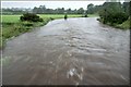
The River Bann at Lindsay's Bridge (3)
See Image The Bann is high after three days of exceptionally heavy rain.
Image: © Albert Bridge
Taken: 15 Jun 2007
0.16 miles
7
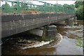
Lindsay's Bridge, Banbridge (2)
See Image This is the bridge after three days of exceptionally heavy rain.
Image: © Albert Bridge
Taken: 15 Jun 2007
0.16 miles
8
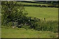
Footbridge at Ballydown, Banbridge
This footbridge crosses a small stream flowing into the Bann at Lindsay’s Bridge. It is used by anglers.
Image: © Albert Bridge
Taken: 9 Jun 2007
0.16 miles
9
The River Bann at Lindsay's Bridge (2)
See Image The water level is very low after a long dry spell and the bottom is clearly visible.
Image: © Albert Bridge
Taken: 29 Apr 2007
0.16 miles
10
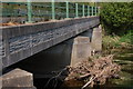
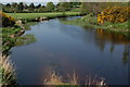
Lindsay's Bridge, Banbridge
See Image This is Lindsay’s Bridge with the Bann flowing from right to left. The water level is very low after a long dry spell. There is quite a pile of detritus against the bridge. Some persistent heavy rain will be needed to increase the flow and remove it.
Image: © Albert Bridge
Taken: 29 Apr 2007
0.16 miles