IMAGES TAKEN NEAR TO
Bannview Heights, BANBRIDGE, BT32 4NA
Introduction
This page details the photographs taken nearby to Bannview Heights, BT32 4NA by members of the Geograph project.
The Geograph project started in 2005 with the aim of publishing, organising and preserving representative images for every square kilometre of Great Britain, Ireland and the Isle of Man.

There are currently over 7.5m images from over14,400 individuals and you can help contribute to the project by visiting https://www.geograph.org.uk
Image Map
Images are licensed for reuse under creativecommons.org/licenses/by-sa/2.0
Notes
- Clicking on the map will re-center to the selected point.
- The higher the marker number, the further away the image location is from the centre of the postcode.
Image Listing (32 Images Found)
Images are licensed for reuse under creativecommons.org/licenses/by-sa/2.0
Image
Details
Distance
2
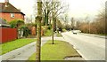
The Lurgan Road, Banbridge
The Lurgan Road, looking towards Seapatrick Image, opposite Bannview Heights. To the best of my knowledge the present line follows that of the Banbridge – Antrim turnpike (which joined the Belfast – Newry turnpike in Banbridge) of the early 19th century replacing the old road (further west) Image The road also forms part of the Banbridge – Portadown road.
Image: © Albert Bridge
Taken: 13 Feb 2009
0.15 miles
3
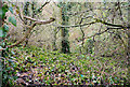
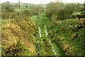
Old railway cutting, Banbridge
See Image This tangled mass of vegetation was once a railway cutting where the line passed under the Lurgan Road. The view is towards what was Banbridge station. The next bridge towards Belfast was here Image
Image: © Albert Bridge
Taken: 28 Feb 2010
0.15 miles
4
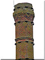
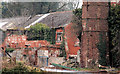
Former Cowdy's mill, Banbridge (2011-4)
The top of the chimney, seen from the other side of the Bann, not on the “at risk” register but perhaps it should be. The strange colour is partly today’s poor light and partly the moss covering the red brickwork.
Image: © Albert Bridge
Taken: 4 Mar 2011
0.21 miles
5
Former Cowdy's mill. Banbridge (2011-3)
The remains of some of the buildings and the base of the chimney - seen from the other side of the Bann. The chimney is not on the “at risk” register but perhaps it should be.
Image: © Albert Bridge
Taken: 4 Mar 2011
0.21 miles
6
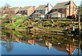
Reflections on the Bann, Banbridge
The cloudless sky and houses of Weaver’s Meadow reflected in the calm waters of the Bann.
Image: © Albert Bridge
Taken: 18 Mar 2009
0.21 miles
7
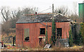
Former Cowdy's mill, Banbridge (2011-1)
The remains of one of the buildings seen from the other side of the Bann.
Image: © Albert Bridge
Taken: 4 Mar 2011
0.22 miles
8
Old railway near Banbridge (2)
See Image This is the same view 27 years before the previous one. There was no encroaching vegetation and the course of the line was still easy to see. In the mid-sixties, when our (relatively new) school rugby field was unplayable after heavy rain, this stretch of old line formed part of our cross-country run (sheer brutality). The old rugby ground, which was very close to here, was nicknamed “Mount Misery”.
Image: © Albert Bridge
Taken: 16 Apr 1980
0.22 miles
9
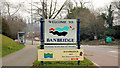
Welcome to Banbridge (2)
The “welcome” sign on the Lurgan Road just out from the Kiln Loanin. Image shows the style used in the 1960’s.
Image: © Albert Bridge
Taken: 4 Mar 2011
0.22 miles
10
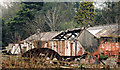
Former Cowdy's mill, Banbridge (2011-2)
The remains of some of the buildings seen from the other side of the Bann.
Image: © Albert Bridge
Taken: 4 Mar 2011
0.23 miles