IMAGES TAKEN NEAR TO
Tudor Oaks, BANBRIDGE, BT32 4LP
Introduction
This page details the photographs taken nearby to Tudor Oaks, BT32 4LP by members of the Geograph project.
The Geograph project started in 2005 with the aim of publishing, organising and preserving representative images for every square kilometre of Great Britain, Ireland and the Isle of Man.

There are currently over 7.5m images from over14,400 individuals and you can help contribute to the project by visiting https://www.geograph.org.uk
Image Map
Images are licensed for reuse under creativecommons.org/licenses/by-sa/2.0
Notes
- Clicking on the map will re-center to the selected point.
- The higher the marker number, the further away the image location is from the centre of the postcode.
Image Listing (15 Images Found)
Images are licensed for reuse under creativecommons.org/licenses/by-sa/2.0
Image
Details
Distance
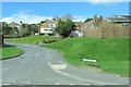
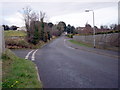
3
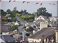
Richmond Heights at its junction with Dromore Street, Banbridge
This is part of the eastern suburbs of Banbridge.
Image: © Eric Jones
Taken: 3 Apr 2017
0.16 miles
4
Ballymoney Hill, Banbridge (2)
Ballymoney Hill, the dominant feature to the north of the town, seen from Downshire Place. “Development” of what might now be called a “natural amenity” started in 1926 with the building of Mount Pleasant.
Image: © Albert Bridge
Taken: 28 Feb 2010
0.18 miles
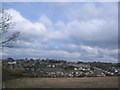
5
Across Banbridge
Looking at Ballymoney Hill
Image: © HENRY CLARK
Taken: 29 Jul 2009
0.19 miles
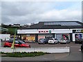
6
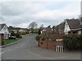
Ballyvalley Heights, Banbridge
This new suburban estate is located off Dromore Street.
Image: © Eric Jones
Taken: 3 Apr 2017
0.19 miles
7
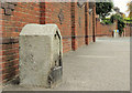
Milestone, Banbridge (2)
A surviving milestone (without the distance plate) on the Dromore Road at Ballyvally Heights - a remnant of the days when Banbridge was on the route of the Belfast – Dublin mail coach. Image (August 2010) shows the one on the Newry Road.
Image: © Albert Bridge
Taken: 15 Sep 2012
0.20 miles
8
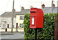
Postbox, Banbridge
Post-mounted EIIR letter box (BT32 11) at the Ballymoney Hill end of Mountpleasant.
Image: © Albert Bridge
Taken: 12 Oct 2013
0.23 miles
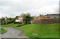
9
Junction of Ballymoney Road and Kiln Lane, Banbridge
Just before The Rowans on the right of the photograph.
Image: © P Flannagan
Taken: 24 Feb 2008
0.23 miles
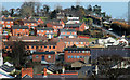
10
Looking West over Banbridge.
Taken on the highest point of Banbridge.
Image: © Peter Lyons
Taken: Unknown
0.24 miles