IMAGES TAKEN NEAR TO
Konver Heights, BANBRIDGE, BT32 4HX
Introduction
This page details the photographs taken nearby to Konver Heights, BT32 4HX by members of the Geograph project.
The Geograph project started in 2005 with the aim of publishing, organising and preserving representative images for every square kilometre of Great Britain, Ireland and the Isle of Man.

There are currently over 7.5m images from over14,400 individuals and you can help contribute to the project by visiting https://www.geograph.org.uk
Image Map
Images are licensed for reuse under creativecommons.org/licenses/by-sa/2.0
Notes
- Clicking on the map will re-center to the selected point.
- The higher the marker number, the further away the image location is from the centre of the postcode.
Image Listing (20 Images Found)
Images are licensed for reuse under creativecommons.org/licenses/by-sa/2.0
Image
Details
Distance
1
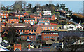
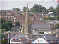
Ballymoney Hill, Banbridge (2)
Ballymoney Hill, the dominant feature to the north of the town, seen from Downshire Place. “Development” of what might now be called a “natural amenity” started in 1926 with the building of Mount Pleasant.
Image: © Albert Bridge
Taken: 28 Feb 2010
0.05 miles
2
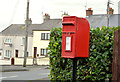
Postbox, Banbridge
Post-mounted EIIR letter box (BT32 11) at the Ballymoney Hill end of Mountpleasant.
Image: © Albert Bridge
Taken: 12 Oct 2013
0.14 miles
3
Ballymoney Hill, Banbridge
Ballymoney Hill seen from Dromore Street Image It was the scene of a fatal Spitfire crash just after WWII.
Image: © Albert Bridge
Taken: 2 Nov 2007
0.14 miles
4
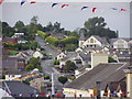
Across Banbridge
Looking at Ballymoney Hill
Image: © HENRY CLARK
Taken: 29 Jul 2009
0.18 miles
5
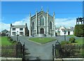
St Patrick's Catholic Church and Presbytery
This church dates from the mid 19thC.
Image: © Eric Jones
Taken: 2 Apr 2011
0.19 miles
8
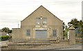
Former parochial hall, Banbridge
The former St Patrick’s parochial hall, at Ballymoney Hill, is now offered for sale with planning permission for 24 apartments. This photograph appears as a matter of record only. I have no connection with any of the parties involved in the sale.
Image: © Albert Bridge
Taken: 12 Oct 2013
0.20 miles
9
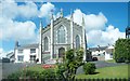
St Patrick's Roman Catholic Church, Dromore Street, Banbridge
This church dates from 1839.
Image: © Eric Jones
Taken: 26 Aug 2011
0.20 miles
10
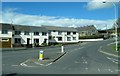
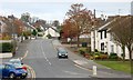
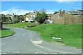
Hill Street, Banbridge, at its junction with Dromore Street
Image: © Eric Jones
Taken: 2 Apr 2011
0.20 miles