IMAGES TAKEN NEAR TO
Cherrywood Court, BANBRIDGE, BT32 3XY
Introduction
This page details the photographs taken nearby to Cherrywood Court, BT32 3XY by members of the Geograph project.
The Geograph project started in 2005 with the aim of publishing, organising and preserving representative images for every square kilometre of Great Britain, Ireland and the Isle of Man.

There are currently over 7.5m images from over14,400 individuals and you can help contribute to the project by visiting https://www.geograph.org.uk
Image Map
Images are licensed for reuse under creativecommons.org/licenses/by-sa/2.0
Notes
- Clicking on the map will re-center to the selected point.
- The higher the marker number, the further away the image location is from the centre of the postcode.
Image Listing (15 Images Found)
Images are licensed for reuse under creativecommons.org/licenses/by-sa/2.0
Image
Details
Distance
1
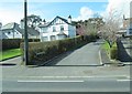
Cherrywood Court off Newry Road, Banbridge
The houses here are typical of the western outskirts of Banbridge.
Image: © Eric Jones
Taken: 2 Apr 2011
0.05 miles
2
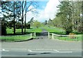
Entrance to the drive of a villa off Newry Road
Image: © Eric Jones
Taken: 2 Apr 2011
0.09 miles
3
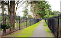
Path, Banbridge
Path running from the Old Newry Road to the Newry Road (background). The existing cemetery is on the left. The area, on the right, makes provision for future expansion.
Image: © Albert Bridge
Taken: 12 Aug 2010
0.10 miles
4
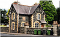
Cemetery gatelodge, Banbridge (1)
The gatelodge, on the Newry Road, at the main entrance to the cemetery. Built of basalt in 1883 and attributed to Young & Mackenzie.
Image: © Albert Bridge
Taken: 12 Aug 2010
0.12 miles
5
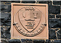
Cemetery gatelodge, Banbridge (2)
The Coat of Arms and date of building, on the gatelodge Image, on the Newry Road. I think, given the date, that the Arms are those of the Banbridge Town Commissioners.
Image: © Albert Bridge
Taken: 12 Aug 2010
0.12 miles
6
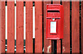
Letter box, Banbridge (2)
Post-mounted EIIR box on the Old Newry Road.
Image: © Albert Bridge
Taken: 12 Aug 2010
0.13 miles
7
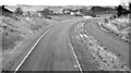
The Banbridge bypass (1981)
See Image The Banbridge bypass, looking towards Belfast from the Bannview Road bridge, when the road was closed for resurfacing. The practice has now changed but, at the time, new roads received a final surface – usually about two years after opening. The absence of the southbound carriageway (right) is described in Image
Image: © Albert Bridge
Taken: 14 Nov 1981
0.19 miles
8
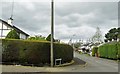
The Grange, Banbridge
This residential close is located off the Newry Road.
Image: © Eric Jones
Taken: 3 Apr 2017
0.19 miles
9
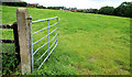
Surviving fields, Banbridge (6)
This one is on the western side of the Old Newry Road.
Image: © Albert Bridge
Taken: 12 Aug 2010
0.21 miles
10
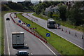
Banbridge bypass, Belfast-Dublin road (2)
For the background to the Banbridge by-pass see Image This is the view towards Dublin from the flyover on the Bannview Road at Tullyear. The cones are in connection with the construction of the flyover mentioned in the link.
Image: © Albert Bridge
Taken: 3 Sep 2006
0.21 miles