IMAGES TAKEN NEAR TO
Drumnagally Road, BANBRIDGE, BT32 3UH
Introduction
This page details the photographs taken nearby to Drumnagally Road, BT32 3UH by members of the Geograph project.
The Geograph project started in 2005 with the aim of publishing, organising and preserving representative images for every square kilometre of Great Britain, Ireland and the Isle of Man.

There are currently over 7.5m images from over14,400 individuals and you can help contribute to the project by visiting https://www.geograph.org.uk
Image Map
Images are licensed for reuse under creativecommons.org/licenses/by-sa/2.0
Notes
- Clicking on the map will re-center to the selected point.
- The higher the marker number, the further away the image location is from the centre of the postcode.
Image Listing (8 Images Found)
Images are licensed for reuse under creativecommons.org/licenses/by-sa/2.0
Image
Details
Distance
3
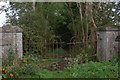
Gateway, Drumnagally Road, Banbridge
This is the gateway to a lane leading to an old house which has been unoccupied for as long as I can remember – indeed the house might not even be there anymore! See Image
Image: © Albert Bridge
Taken: 22 Oct 2006
0.23 miles
4
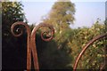
Gate, Smyth's Hill, Banbridge
See Image and Image This is the same gateway in 1969. The gate was intact but the lane was not as overgrown.
Image: © Albert Bridge
Taken: Unknown
0.23 miles
5
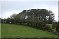
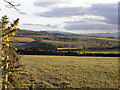
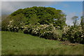
Listullyard fort near Banbridge
Listullyard fort is a rath - for an explanation see Image There is a view from the fort as far as Lough Neagh. It was always known locally as “Lisleyard Forth”. This pronunciation is acknowledged in “Place-Names of Northern Ireland – County Down IV”. Continue to Image
Image: © Albert Bridge
Taken: 22 Oct 2006
0.23 miles
6
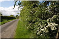
The Drumnagally Road, Banbridge (2)
See Image This is the same stretch of road but with the Spring flowers on display.
Image: © Albert Bridge
Taken: 19 May 2007
0.23 miles
7
Listullyard fort near Banbridge (2)
Image: © Albert Bridge
Taken: 19 May 2007
0.23 miles
8
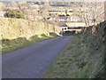
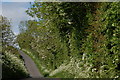
The Listullyard Road near Banbridge
See Image This is the Listullyard Road – a narrow road which passes the rath. The rath is behind the photographer, to the right.
Image: © Albert Bridge
Taken: 19 May 2007
0.23 miles