IMAGES TAKEN NEAR TO
Ballydown Road, BANBRIDGE, BT32 3RP
Introduction
This page details the photographs taken nearby to Ballydown Road, BT32 3RP by members of the Geograph project.
The Geograph project started in 2005 with the aim of publishing, organising and preserving representative images for every square kilometre of Great Britain, Ireland and the Isle of Man.

There are currently over 7.5m images from over14,400 individuals and you can help contribute to the project by visiting https://www.geograph.org.uk
Image Map
Images are licensed for reuse under creativecommons.org/licenses/by-sa/2.0
Notes
- Clicking on the map will re-center to the selected point.
- The higher the marker number, the further away the image location is from the centre of the postcode.
Image Listing (26 Images Found)
Images are licensed for reuse under creativecommons.org/licenses/by-sa/2.0
Image
Details
Distance
1
Old railway bridge, Banbridge
The surviving and overgrown abutments of the bridge which carried the Knockmore Jct/Banbridge – Castlewellan GNR(I) line across the Ballydown Road Image The line closed in 1955. The view is towards the Rathfriland Road.
Image: © Albert Bridge
Taken: 19 May 2009
0.03 miles
2
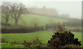
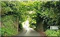
Misty fields, Banbridge (1)
A heavy mist hanging over Ballydown, near Lindsay’s Bridge, making a gloomy scene. The Ballydown Road Image is marked by the hedge running across the photo.
Image: © Albert Bridge
Taken: 14 Nov 2010
0.04 miles
3
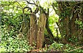
Old railway fence, Banbridge
54 years after the line closed, part of the sleeper fence still survives, beside the old bridge Image, on the Ballydown Road. It says something about the quality of the creosote used by the GNR(I) – bearing in mind that they were probably from re-laid track before being recycled as fence posts.
Image: © Albert Bridge
Taken: 19 May 2009
0.06 miles
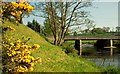
4
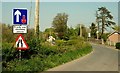
Road signs, Ballydown, Banbridge
Two cars can cross on the Ballydown Road but not on Lindsay’s Bridge Image The bridge is at the middle right with the Young Farmers hall on the right. The view is towards the Castlewellan Road.
Image: © Albert Bridge
Taken: 7 May 2008
0.06 miles
5
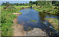
The low River Bann, Banbridge
The River Bann, looking downstream from Lindsay’s Bridge, at a very low level after the present long hot and dry spell. Image shows a contrasting view in August 2008.
Image: © Albert Bridge
Taken: 20 Jul 2013
0.09 miles
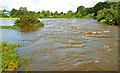
6
The Bann in flood (2)
Image: © Albert Bridge
Taken: 17 Aug 2008
0.10 miles
7
The River Bann at Lindsay's Bridge (5)
See Image The view upstream with the whins at their peak.
Image: © Albert Bridge
Taken: 7 May 2008
0.12 miles
8
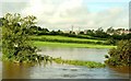
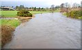
The Bann in flood (1)
There has been heavy and persistent rain over the last 2-3 weeks followed by a deluge on 16 August. The Bann reached an abnormally high level. This is the first in a series of shots of the river around Banbridge. The view is downstream from Lindsay’s Bridge at Ballydown. This Image shows the Bann at its “normal” level. The common point of reference is the Armaghdown Creamery (top left). Continue to Image For a complete contrast see Image (July 2013).
Image: © Albert Bridge
Taken: 17 Aug 2008
0.12 miles
9
The River Bann at Lindsay's Bridge (4)
See Image The same view but with the Bann slightly higher after several days of frequent heavy rain.
Image: © Albert Bridge
Taken: 13 Jan 2008
0.12 miles
10
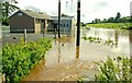
The Bann in flood (5)
See Image Ballydown Young Farmers Hall had received more than its fair share of the Bannwater. Continue to Image
Image: © Albert Bridge
Taken: 17 Aug 2008
0.12 miles