IMAGES TAKEN NEAR TO
Maryville Close, BANBRIDGE, BT32 3QY
Introduction
This page details the photographs taken nearby to Maryville Close, BT32 3QY by members of the Geograph project.
The Geograph project started in 2005 with the aim of publishing, organising and preserving representative images for every square kilometre of Great Britain, Ireland and the Isle of Man.

There are currently over 7.5m images from over14,400 individuals and you can help contribute to the project by visiting https://www.geograph.org.uk
Image Map
Images are licensed for reuse under creativecommons.org/licenses/by-sa/2.0
Notes
- Clicking on the map will re-center to the selected point.
- The higher the marker number, the further away the image location is from the centre of the postcode.
Image Listing (54 Images Found)
Images are licensed for reuse under creativecommons.org/licenses/by-sa/2.0
Image
Details
Distance
1
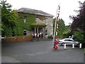
Belmont Hotel, Banbridge
We stopped briefly here for tea and scones
Image: © Kenneth Allen
Taken: 3 Aug 2009
0.10 miles
2
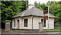
"Belmont" gate lodge, Banbridge
“Belmont” was built, to a design by Thomas Jackson, circa 1860 for a local linen manufacturer. The gate lodge (now vacant) is thought to be from the same date. Boarded up and on the “Art Risk” register.
Image: © Albert Bridge
Taken: 17 Jul 2010
0.14 miles
3
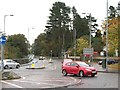
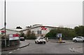
Tesco traffic island on Rathfriland Road, Banbridge
Image: © Eric Jones
Taken: 6 Nov 2013
0.14 miles
4
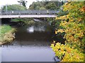
Bridge across the Bann leading to Tesco Banbridge
This image was taken from the wooden footbridge at the southern end of Solitude Park.
Image]
Image: © Eric Jones
Taken: 6 Nov 2013
0.15 miles
5
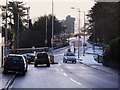
Kenlis Street and Rathfriland Road, Banbridge
The view down Kenlis Street from outside Mills' coal stores. The little roundabout in the centre regulates traffic appeared in order to ease congestion for traffic leaving Tesco's.
The main Rathfriland Road continues towards the creamery and the A1 Bypass.
Image: © Dean Molyneaux
Taken: 21 Dec 2009
0.16 miles
6
The entrance to Tesco Banbridge from Rathfriland Road
The entrance road crosses the River Bann.
Image]
Image: © Eric Jones
Taken: 6 Nov 2013
0.16 miles
8
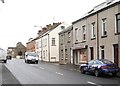
Kenlis Street, Banbridge
Kenlis Street was laid out around 1866 when it connected Newry Street to Rathfriland Street and the Rathfriland Road. The street was realigned at the western end to connect into the new roundabout Image The old bit (opposite the war memorial) was re-named “Old Kenlis Street”. This is the view outwards at Townsend Street. Once upon a time the Ormeau Bakery Image had a depot (near the dark car on the left) where it kept its breadvans for door-to-door deliveries. In those distant times it was in local competition with Inglis (“English’s”) and Preston’s. Some might remember that the breadman had a long pole which he used to pull out the drawers in the breadvans.
Image: © Albert Bridge
Taken: 17 Jul 2010
0.18 miles
9
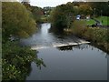
Weir on the River Bann in Solitude Park
This image was taken from the wooden footbridge.
Image: © Eric Jones
Taken: 6 Nov 2013
0.18 miles
10
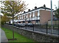
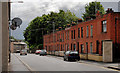
Maisonettes in Rathfriland Road, Banbridge
Image: © Eric Jones
Taken: 6 Nov 2013
0.19 miles