IMAGES TAKEN NEAR TO
Maglion Terrace, BANBRIDGE, BT32 3QU
Introduction
This page details the photographs taken nearby to Maglion Terrace, BT32 3QU by members of the Geograph project.
The Geograph project started in 2005 with the aim of publishing, organising and preserving representative images for every square kilometre of Great Britain, Ireland and the Isle of Man.

There are currently over 7.5m images from over14,400 individuals and you can help contribute to the project by visiting https://www.geograph.org.uk
Image Map
Images are licensed for reuse under creativecommons.org/licenses/by-sa/2.0
Notes
- Clicking on the map will re-center to the selected point.
- The higher the marker number, the further away the image location is from the centre of the postcode.
Image Listing (1 Images Found)
Images are licensed for reuse under creativecommons.org/licenses/by-sa/2.0
Image
Details
Distance
1
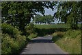
The Ringsend Road near Banbridge
This is the section of the Ringsend Road between Hill’s Cross Roads and the Banbridge – Scarva road. It might look rural but the ever-expanding Banbridge is lurking, not too far away, out of sight, to the right. The view is towards the Scarva Road.
Image: © Albert Bridge
Taken: 9 Jun 2007
0.16 miles