IMAGES TAKEN NEAR TO
Scarva Road, BANBRIDGE, BT32 3QD
Introduction
This page details the photographs taken nearby to Scarva Road, BT32 3QD by members of the Geograph project.
The Geograph project started in 2005 with the aim of publishing, organising and preserving representative images for every square kilometre of Great Britain, Ireland and the Isle of Man.

There are currently over 7.5m images from over14,400 individuals and you can help contribute to the project by visiting https://www.geograph.org.uk
Image Map
Images are licensed for reuse under creativecommons.org/licenses/by-sa/2.0
Notes
- Clicking on the map will re-center to the selected point.
- The higher the marker number, the further away the image location is from the centre of the postcode.
Image Listing (13 Images Found)
Images are licensed for reuse under creativecommons.org/licenses/by-sa/2.0
Image
Details
Distance
1
Drop box and letter box, Banbridge
Drop box and post-mounted EIIR letter box, at Grove Meadows on the Scarva Road (shown as “Ravenswood” and “Moyle Road” on the Google map).
Image: © Albert Bridge
Taken: 16 Oct 2011
0.12 miles
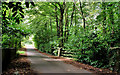
2
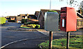
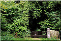
The private entrance to Brookfield House, Banbridge (1)
See Image This is a view of the lane leading to the private residence of the former owner. My memories go back to the early 60’s and it was closed and padlocked even then. The only changes seem to be that the trees are taller and wider!
See also Image
Image: © Albert Bridge
Taken: 3 Sep 2006
0.15 miles
3
The private entrance to Brookfield House, Banbridge (2)
See Image This is a view, taken in September 1969, of the lane leading to the private residence of the former owner of Brookfield Mill. The trees have grown considerably with the passage of 37 years. For the view in 2010 see Image
Image: © Albert Bridge
Taken: Unknown
0.15 miles
4
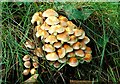
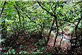
Fungus, Banbridge
Fungus growing on an old tree stump, beside the lane at Brookfield Image
Image: © Albert Bridge
Taken: 2 Aug 2008
0.15 miles
5
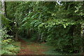
The drive to Brookfield, Banbridge
See Image This is a view of the drive leading to the former Brookfield Mill and the private residence of the owner.
Image: © Albert Bridge
Taken: 3 Sep 2006
0.17 miles
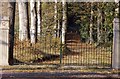
6
Gate, Brookfield, Banbridge
See Image The same gate – 41 years later and still chained.
Image: © Albert Bridge
Taken: 28 Aug 2010
0.18 miles
7
Brookfield dam, Banbridge
Cheating because not only is the dam dry (it was drying 45 years ago) but it’s not accessible through the thick vegetation. This is its feeder stream seen from here Image
Image: © Albert Bridge
Taken: 28 Aug 2010
0.19 miles
8
Bridge, Brookfield, Banbridge
This bridge (which seems to have been widened at some time) carries the Brookfield Road Image across this stream Image
Image: © Albert Bridge
Taken: 28 Aug 2010
0.19 miles
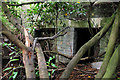
9
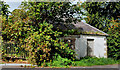
Former gate lodge, Brookfield, Banbridge (3)
See Image The other (western) former gate lodge – the view of the town side of the building. Also on the “At Risk” register.
Image: © Albert Bridge
Taken: 28 Aug 2010
0.20 miles
10
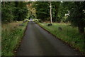
The Brookfield Road, Banbridge (1)
The view towards here Image and the Scarva Road, at the bridge where the road crosses the stream that fed the dam.
Image: © Albert Bridge
Taken: 28 Aug 2010
0.20 miles