IMAGES TAKEN NEAR TO
Scarva Street, BANBRIDGE, BT32 3NH
Introduction
This page details the photographs taken nearby to Scarva Street, BT32 3NH by members of the Geograph project.
The Geograph project started in 2005 with the aim of publishing, organising and preserving representative images for every square kilometre of Great Britain, Ireland and the Isle of Man.

There are currently over 7.5m images from over14,400 individuals and you can help contribute to the project by visiting https://www.geograph.org.uk
Image Map
Images are licensed for reuse under creativecommons.org/licenses/by-sa/2.0
Notes
- Clicking on the map will re-center to the selected point.
- The higher the marker number, the further away the image location is from the centre of the postcode.
Image Listing (23 Images Found)
Images are licensed for reuse under creativecommons.org/licenses/by-sa/2.0
Image
Details
Distance
1
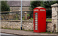
Telephone box, Loughbrickland
Image: © Albert Bridge
Taken: 27 Jan 2011
0.01 miles
2
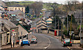
Scarva Street, Loughbrickland
Scarva Street (foreground) leading to Main Street, the Dublin Road and the southern end of the bypass, showing (I hope) the village’s position among the drumlins of west Down.
Image: © Albert Bridge
Taken: 27 Jan 2011
0.03 miles
3
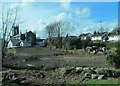
Building site in the rear of Loughbrickland's St Patrick's Catholic Church
St Patrick's Church, built in the gothic style, was completed in 1832. Part of the total building costs of £1,700 was provided by the Protestants of Loughbrickland. Today the proportion of Roman Catholics and Protestants in the local community is about equal.
Image: © Eric Jones
Taken: 2 Apr 2011
0.05 miles
4
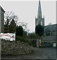
The spire of St Mellon's CoI Parish Church, Loughbrickland
Image: © Eric Jones
Taken: 2 Apr 2011
0.09 miles
5
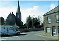
St Mellon's CoI Parish Church, Loughbrickland
The earliest St Mellon's parish church on this site was established in 1611 by Sir Marmaduke Whitechurch, who also was the owner of the historic Killevy churches near Meigh. This church was destroyed in the Irish Uprising of 1641. The present building dates mainly from 1688.
Image
Image: © Eric Jones
Taken: 2 Apr 2011
0.09 miles
6
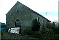
Tea Rooms adjacent to St Mellon's Church, Loughbrickland
Image: © Eric Jones
Taken: 2 Apr 2011
0.10 miles
7
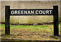
Street sign, Loughbrickland
The standard form of street sign, used by Banbridge District Council in Loughbrickland. This one is at Greenan Court on the Banbridge Road.
Image: © Albert Bridge
Taken: 27 Jan 2011
0.10 miles
8
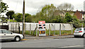
Development site, Loughbrickland
A vacant site, at Scarva Street, opposite the Old Newry Road, offered for sale with planning permission for four townhouses. This photograph appears as a matter of record only. I have no connection with any of the parties involved in the sale.
Image: © Albert Bridge
Taken: 19 May 2012
0.12 miles
9
Letters box, Loughbrickland
Wall-mounted box at Main Street. Don’t know whether it’s a clever reproduction (it includes the name “Carronade”) or a piece of Royal Mail surplus. The notice plate is black which should help avoid confusion although I didn’t check to see whether the slot is open or a blank.
Image: © Albert Bridge
Taken: 19 May 2012
0.13 miles
10
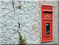
Pillar box, Loughbrickland
GR pillar box, outside the post office, in Main Street.
Image: © Albert Bridge
Taken: 27 Jan 2011
0.15 miles