IMAGES TAKEN NEAR TO
Huntly Road, BANBRIDGE, BT32 3BJ
Introduction
This page details the photographs taken nearby to Huntly Road, BT32 3BJ by members of the Geograph project.
The Geograph project started in 2005 with the aim of publishing, organising and preserving representative images for every square kilometre of Great Britain, Ireland and the Isle of Man.

There are currently over 7.5m images from over14,400 individuals and you can help contribute to the project by visiting https://www.geograph.org.uk
Image Map
Images are licensed for reuse under creativecommons.org/licenses/by-sa/2.0
Notes
- Clicking on the map will re-center to the selected point.
- The higher the marker number, the further away the image location is from the centre of the postcode.
Image Listing (49 Images Found)
Images are licensed for reuse under creativecommons.org/licenses/by-sa/2.0
Image
Details
Distance
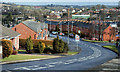
1
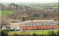
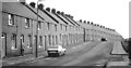
Edenderry Gardens, Banbridge
See Image Opened one year later by the old Banbridge UDC, Edenderry Gardens is similar in design to its near neighbour. Peggy’s Loanin Image runs close to the bottom of the photo.
Image: © Albert Bridge
Taken: 21 Feb 2009
0.02 miles
2
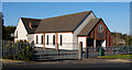
Banbridge Independent Methodist church
Built close to the site of Image
Image: © Albert Bridge
Taken: 30 Jan 2010
0.02 miles
3
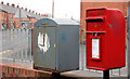
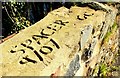
Letter box, Banbridge
Post-mounted EIIR letter box and a drop box at the Peggy’s Loanin end of the Huntly Road. Golf Terrace Image is in the background (left).
Image: © Albert Bridge
Taken: 4 Mar 2011
0.02 miles
4
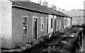
Derelict cottages, Banbridge
A row of vacant cottages, near the bottom of Peggy’s Loanin, long since demolished. Back in the 1960’s there was no mains water supply. Water was obtained from a stand pipe at the end of the Huntly Road, near the entrance to Cowdy’s footbridge. See also Image
Image: © Albert Bridge
Taken: 13 Dec 1979
0.03 miles
5
Golf Terrace, Banbridge (2)
See Image An earlier view – in the days before the satellite dish.
Image: © Albert Bridge
Taken: 13 Dec 1979
0.07 miles
6
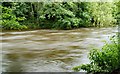
The Bann at Banbridge (6)
See Image The view upstream from close to the same place (allowing for a new safety fence) with the Bann high, mighty and muddy after a long spell of persistent rain.
Image: © Albert Bridge
Taken: 14 Aug 2008
0.09 miles
7
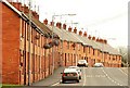
Golf Terrace, Banbridge
Completed in 1930 (apparently at a cost of £8,600), Golf Terrace, on the Huntly Road, was the second housing scheme undertaken by the old Banbridge UDC (the first was Mountpleasant in 1926). See also Image and Image
Image: © Albert Bridge
Taken: 14 Feb 2009
0.11 miles
8
Graffiti, Banbridge
Graffiti on the wall on the Dunbar Road Image Before you despatch an indignant letter to the “Chronicle” remember that there was graffiti on cave walls 30,000 years ago.
Image: © Albert Bridge
Taken: 18 Mar 2009
0.11 miles
9
Peggy's Loanin, Banbridge (2)
See Image The view in the opposite direction (towards the Huntly Road). The long redbrick terrace on the right is Edenderry Gardens Image
Image: © Albert Bridge
Taken: 28 Feb 2010
0.12 miles
10
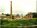
Former Cowdy's Mill, Banbridge (2008)
See Image For comparison today – some buildings have been demolished (revealing the waterwheel) and the vegetation has grown considerably, partly hiding the Bann. The chimney is not on the “at risk” register but perhaps it should be.
Image: © Albert Bridge
Taken: 10 Jul 2008
0.12 miles