IMAGES TAKEN NEAR TO
Kilnhill Road, CASTLEWELLAN, BT31 9TE
Introduction
This page details the photographs taken nearby to Kilnhill Road, BT31 9TE by members of the Geograph project.
The Geograph project started in 2005 with the aim of publishing, organising and preserving representative images for every square kilometre of Great Britain, Ireland and the Isle of Man.

There are currently over 7.5m images from over14,400 individuals and you can help contribute to the project by visiting https://www.geograph.org.uk
Image Map
Images are licensed for reuse under creativecommons.org/licenses/by-sa/2.0
Notes
- Clicking on the map will re-center to the selected point.
- The higher the marker number, the further away the image location is from the centre of the postcode.
Image Listing (12 Images Found)
Images are licensed for reuse under creativecommons.org/licenses/by-sa/2.0
Image
Details
Distance
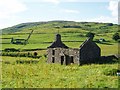
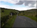
2
The shell of a house west of Kilnhill Road
This is situated just south of the junction with Ardglass Road. Legananny Mountain forms the background.
Image: © Eric Jones
Taken: 23 Aug 2011
0.09 miles
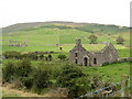
3
Derelict house off the Kilnhill Road
This long abandoned house is just off the Kilnhill road, the Mourne Mountains are in the far distance.
Image: © Martyn Pattison
Taken: 22 Aug 2010
0.09 miles
4
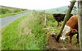
The Ardglass Road near Finnis (1)
A minor road running through high ground to the SSE of Finnis and Dromara. The land provides grazing for beef cattle. See also Image
Image: © Albert Bridge
Taken: 25 Jul 2008
0.14 miles
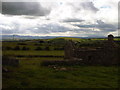
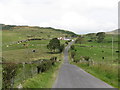
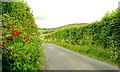
5
Looking North along the Kilnhill Road
Image: © Martyn Pattison
Taken: 22 Aug 2010
0.15 miles
6
The V-shaped valley of the Leitrim River downstream of Fry's Bridge
This is a classic V-shaped valley with interlocking spurs.
Image: © Eric Jones
Taken: 23 Aug 2011
0.19 miles
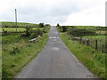
7
Kilnhill Road crossing Fry's Bridge over the Leitrim River and rising up to the col
The river here is in its infancy being about a mile from its source. The river enters the sea, as the Corrigs River, in Dundrum Inner Bay.
Image: © Eric Jones
Taken: 23 Aug 2011
0.20 miles
8
Fry's Bridge on Kilnhill Road
This is the view south across the bridge which spans the Leitrim River.
Image: © Eric Jones
Taken: 23 Aug 2011
0.20 miles
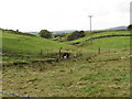
9
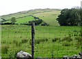
Hill grazings on the east side of Kilnhill Road
The land use contrasts with that on the large drumlin to the west of the road.
Image]
Image: © Eric Jones
Taken: 23 Aug 2011
0.22 miles
10
The Dolmen Road near Finnis
Image: © Albert Bridge
Taken: 15 Jun 2008
0.23 miles