IMAGES TAKEN NEAR TO
Clonvaraghan Road, CASTLEWELLAN, BT31 9TA
Introduction
This page details the photographs taken nearby to Clonvaraghan Road, BT31 9TA by members of the Geograph project.
The Geograph project started in 2005 with the aim of publishing, organising and preserving representative images for every square kilometre of Great Britain, Ireland and the Isle of Man.

There are currently over 7.5m images from over14,400 individuals and you can help contribute to the project by visiting https://www.geograph.org.uk
Image Map
Images are licensed for reuse under creativecommons.org/licenses/by-sa/2.0
Notes
- Clicking on the map will re-center to the selected point.
- The higher the marker number, the further away the image location is from the centre of the postcode.
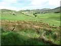
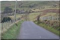
Image Listing (4 Images Found)
Images are licensed for reuse under creativecommons.org/licenses/by-sa/2.0
Image
Details
Distance
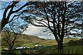
2
View across the upper reaches of the valley towards Slieve Croob
Slieve Croob is easily identifiable from the telecommunications masts on its summit. The houses are on Clonvaraghan Road. The stream, not named on the map, is a tributary of the Moneycarragh River. The image was taken from the Ardglass Road.
Image: © Eric Jones
Taken: 19 May 2016
0.14 miles
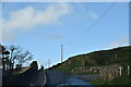
3
Clonvaraghan Road
Looking towards Castlewellan
Image: © HENRY CLARK
Taken: 3 Jan 2009
0.22 miles