IMAGES TAKEN NEAR TO
Flush Road, CASTLEWELLAN, BT31 9SB
Introduction
This page details the photographs taken nearby to Flush Road, BT31 9SB by members of the Geograph project.
The Geograph project started in 2005 with the aim of publishing, organising and preserving representative images for every square kilometre of Great Britain, Ireland and the Isle of Man.

There are currently over 7.5m images from over14,400 individuals and you can help contribute to the project by visiting https://www.geograph.org.uk
Image Map
Images are licensed for reuse under creativecommons.org/licenses/by-sa/2.0
Notes
- Clicking on the map will re-center to the selected point.
- The higher the marker number, the further away the image location is from the centre of the postcode.
Image Listing (10 Images Found)
Images are licensed for reuse under creativecommons.org/licenses/by-sa/2.0
Image
Details
Distance
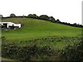
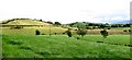
1
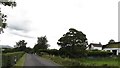
Houses above Flush Road
This quiet road leads on to the busy A50 Castlewellan to Banbridge Road.
Image: © Eric Jones
Taken: 15 Aug 2014
0.01 miles
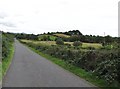
2
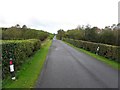
Flush Road
Heading south-west to Drumadonnell
Image: © Kenneth Allen
Taken: 12 Oct 2011
0.04 miles
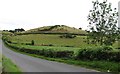
3
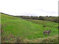
Donkey, White Hill
Looking south-east from Flush Road
Image: © Kenneth Allen
Taken: 12 Oct 2011
0.04 miles
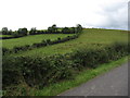
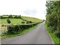
4
The stoss end of a drumlin above Flush Road
The tall trees mark the site of a rath. A rath is a walled enclosure dating back to the tribal period.
Image: © Eric Jones
Taken: 15 Aug 2014
0.06 miles
6
The north side of White Hill from Flush Road
White Hill is a typical drumlin.
Image: © Eric Jones
Taken: 15 Aug 2014
0.20 miles
7
View east towards the White Hill drumlin
Image: © Eric Jones
Taken: 15 Aug 2014
0.21 miles
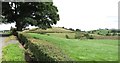
8
White Hill drumlin and inter-drumlin wetland seen from the Flush Road
Image: © Eric Jones
Taken: 15 Aug 2014
0.22 miles
9
White Hill from the Flash Road/Eelwire Road junction
Image: © Eric Jones
Taken: 15 Aug 2014
0.23 miles