IMAGES TAKEN NEAR TO
Moneyslane Road, CASTLEWELLAN, BT31 9QD
Introduction
This page details the photographs taken nearby to Moneyslane Road, BT31 9QD by members of the Geograph project.
The Geograph project started in 2005 with the aim of publishing, organising and preserving representative images for every square kilometre of Great Britain, Ireland and the Isle of Man.

There are currently over 7.5m images from over14,400 individuals and you can help contribute to the project by visiting https://www.geograph.org.uk
Image Map
Images are licensed for reuse under creativecommons.org/licenses/by-sa/2.0
Notes
- Clicking on the map will re-center to the selected point.
- The higher the marker number, the further away the image location is from the centre of the postcode.
Image Listing (26 Images Found)
Images are licensed for reuse under creativecommons.org/licenses/by-sa/2.0
Image
Details
Distance
1
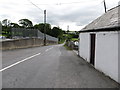
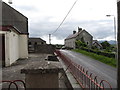
The north western end of Ballymackilreiny Road
The metal fence surrounds the yard of P Turley & Sons, Hardware Merchants. Ballymackkilreiny Road leads towards Ballyward.
Image: © Eric Jones
Taken: 15 Aug 2014
0.00 miles
2
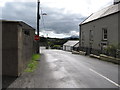
Lowtown/Dechomet cross roads from Croskelt Road
The image was taken from the gate of the chapel.
Image: © Eric Jones
Taken: 15 Aug 2014
0.01 miles
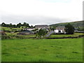
3
Approaching the Lowtown cross roads
Lowtown is a hamlet which has grown around the cross roads.
Image: © Eric Jones
Taken: 15 Aug 2014
0.01 miles
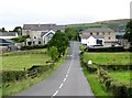
4
The village of Lowtown /Dechomet from the south
A mainly Nationalist community, Lowtown is centred on a cross roads on the Moneyslane Road a little over a mile north east of the Loyalist village of Moneyslane.
Image: © Eric Jones
Taken: 15 Aug 2014
0.01 miles
5
The eastern end of Croskelt Road
The image was taken from the chapel grounds.
Image: © Eric Jones
Taken: 15 Aug 2014
0.02 miles
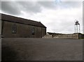
7
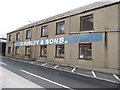
P Turley & Sons Hardware Merchant at Lowtown/Dechomet
This is a traditional hardware business located on Moneyslane Road. Established in the early 1900s, this family run business supplies the needs of both farmers and builders.
Image: © Eric Jones
Taken: 15 Aug 2014
0.03 miles
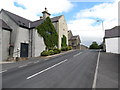
8
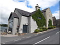
St Mary's Chapel, Lowtown/Dechomet
This image was taken from Ballymackilreny Road.
Image: © Eric Jones
Taken: 15 Aug 2014
0.03 miles
9
St Mary's Chapel, Lowtown/Dechomet
This plain stone building dates from 1835. Some thirty years earlier a smaller church had been built on the site of present church. At that time Sunday Mass attendence was said to be around 600. During the 19th and 20th centuries depopulation reduced the number of parishioners. Today, the church is served by the priest from the village of Leitrim.
Image: © Eric Jones
Taken: 15 Aug 2014
0.03 miles
10
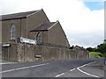
The Moneyslane Road entering Lowtown/Dechomet from the south
Lowtown is situated on rising ground,
Image: © Eric Jones
Taken: 15 Aug 2014
0.04 miles