IMAGES TAKEN NEAR TO
Dunturk Road, CASTLEWELLAN, BT31 9PF
Introduction
This page details the photographs taken nearby to Dunturk Road, BT31 9PF by members of the Geograph project.
The Geograph project started in 2005 with the aim of publishing, organising and preserving representative images for every square kilometre of Great Britain, Ireland and the Isle of Man.

There are currently over 7.5m images from over14,400 individuals and you can help contribute to the project by visiting https://www.geograph.org.uk
Image Map
Images are licensed for reuse under creativecommons.org/licenses/by-sa/2.0
Notes
- Clicking on the map will re-center to the selected point.
- The higher the marker number, the further away the image location is from the centre of the postcode.
Image Listing (9 Images Found)
Images are licensed for reuse under creativecommons.org/licenses/by-sa/2.0
Image
Details
Distance
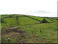
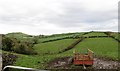
2
A rath on a drumlin ridge on the west side of Dunturk Road
This known locally as Burns Forth and it overlooks the Moneycarragh valley. The High Mournes can be seen in the background.
http://apps.ehsni.gov.uk/ambit/docs/DOW/DOW_036/DOW_036_006/Public/SM7-DOW-036-006.pdf
Image: © Eric Jones
Taken: 31 Oct 2015
0.09 miles
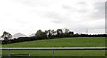
4
Valley between two elongated drumlin ridges
The image was taken eastwards from Dunturk Road.
Image: © Eric Jones
Taken: 31 Oct 2015
0.10 miles
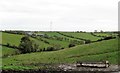
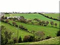
5
Geometric field pattern on drumlin
These are mostly hedges, but often with stone walls along the spines of the drumlins. This large drumlin runs parallel with both Dunturk Road and Carnreagh Road. The peak on the left is Dunturk Mountain.
Dunturk Hill is an outpost of the Slieve Croob Range. Composed of igneous rocks between 250 and 400 million years old it stands above the surrounding drumlins formed by moving ice only some 13,000 years ago.
Image: © Eric Jones
Taken: 31 Oct 2015
0.18 miles
6
A scheduled rath on a drumlin slope between Dunturk and Carnreagh Roads
This well preserved rath dates from the early Christian period.
http://apps.ehsni.gov.uk/ambit/Details.aspx?MonID=7964
Image: © Eric Jones
Taken: 31 Oct 2015
0.21 miles
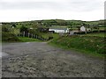
7
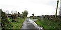
Farm buildings on Dunturk Road
This locality has a small clachan of homesteads.
Image: © Eric Jones
Taken: 31 Oct 2015
0.21 miles
8
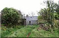
Disused long house homestead on the Dunturk Road
Image: © Eric Jones
Taken: 31 Oct 2015
0.22 miles
9
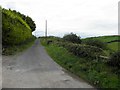
Farm entrance lane on the west side of Dunturk Road
Image: © Eric Jones
Taken: 31 Oct 2015
0.24 miles