IMAGES TAKEN NEAR TO
Corry Wood Park, CASTLEWELLAN, BT31 9NP
Introduction
This page details the photographs taken nearby to Corry Wood Park, BT31 9NP by members of the Geograph project.
The Geograph project started in 2005 with the aim of publishing, organising and preserving representative images for every square kilometre of Great Britain, Ireland and the Isle of Man.

There are currently over 7.5m images from over14,400 individuals and you can help contribute to the project by visiting https://www.geograph.org.uk
Image Map
Images are licensed for reuse under creativecommons.org/licenses/by-sa/2.0
Notes
- Clicking on the map will re-center to the selected point.
- The higher the marker number, the further away the image location is from the centre of the postcode.
Image Listing (23 Images Found)
Images are licensed for reuse under creativecommons.org/licenses/by-sa/2.0
Image
Details
Distance
1
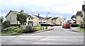
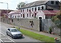
Corry Wood Park Estate, Castlewellan
This recently built estate is located off the A25 between Castlewellan and Annsborough.
Image: © Eric Jones
Taken: 7 Jun 2017
0.01 miles
3
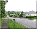
Entering Annsborough on the A25 from the direction of Castlewellan
Beyond Annsborough the road climbs up steeply at Ardnabannon.
Image: © Eric Jones
Taken: 28 Aug 2014
0.05 miles
5

The Clarkhill Road junction between Annsborough and Castlewellan
Image: © Eric Jones
Taken: 20 Sep 2021
0.07 miles
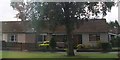
6
Feedwell Dog Food Plant, Annsborough
This company is based in a former linen mill.
Image: © Eric Jones
Taken: 29 Jul 2011
0.08 miles
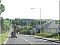
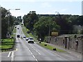
7
The A25 descending down into Annsborough
Beyond it climbs equally steeply up Ardnabannon Hill.
Image: © Eric Jones
Taken: 7 Jun 2017
0.11 miles
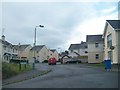
8

Modern housing estate on the site of a former linen mill
Image: © Eric Jones
Taken: 20 Sep 2021
0.11 miles
9
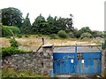
The site of a now demolished linen mill at Annsborough
The mill can be seen on the 2008 images of Google Street View.
Image: © Eric Jones
Taken: 2 Aug 2013
0.11 miles
10
Approaching Mill Hill from the Annsborough Direction
Mill Hill climbs steeply up to the town of Castlewellan. The road is the A25 which runs from the Monaghan/Armagh border near Castleblayney to Strangford at the mouth of Strangford Lough.
Image: © Eric Jones
Taken: 29 Jul 2011
0.12 miles