IMAGES TAKEN NEAR TO
Slievehanny Road, CASTLEWELLAN, BT31 9LW
Introduction
This page details the photographs taken nearby to Slievehanny Road, BT31 9LW by members of the Geograph project.
The Geograph project started in 2005 with the aim of publishing, organising and preserving representative images for every square kilometre of Great Britain, Ireland and the Isle of Man.

There are currently over 7.5m images from over14,400 individuals and you can help contribute to the project by visiting https://www.geograph.org.uk
Image Map
Images are licensed for reuse under creativecommons.org/licenses/by-sa/2.0
Notes
- Clicking on the map will re-center to the selected point.
- The higher the marker number, the further away the image location is from the centre of the postcode.
Image Listing (12 Images Found)
Images are licensed for reuse under creativecommons.org/licenses/by-sa/2.0
Image
Details
Distance
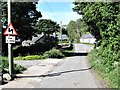
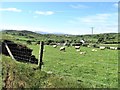
2

Flowery meadow alongside the Slievehanny Road
Slievehanny mountain forms the background.
Image: © Eric Jones
Taken: 19 May 2016
0.04 miles
3

Farm outbuildings on the Slievehanny Road
These stand across the road from the farmhouse.
Image]
Image: © Eric Jones
Taken: 19 May 2016
0.05 miles
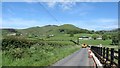
4
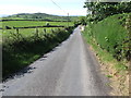
View SSW along Slievehanny Road
This is part of the northern section of the road. The high ground in the middle ground are Slievehanny and Clonvaraghan mountains. In the far distance are the peaks of the High Mournes.
Image: © Eric Jones
Taken: 19 May 2016
0.08 miles
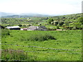
5
Valley floor farmhouses and outbuildings in the shadow of Seeconnell
The image was taken from the Slievehanny Road.
Image: © Eric Jones
Taken: 19 May 2016
0.09 miles
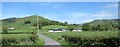
6
View north eastwards across the valley floor from the lower slopes of Slievehanny
Beyond the drumlin belt of the valley floor are the two highest mountains the Slieve Croob range. They are Slieve Croob (534m) and, on the right, Slievenisky (446m).
Image: © Eric Jones
Taken: 19 May 2016
0.14 miles
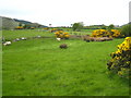
7
Grazing land west of the upper end of Slievehanny Road
Image: © Eric Jones
Taken: 19 May 2016
0.17 miles
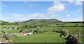
8
Tractor and low loader descending to the valley floor along Slievehanny Road
The two mountains in the background are Slievegarran and, in front of it, Seeconnell. The valley is not named on the map.
Image: © Eric Jones
Taken: 19 May 2016
0.19 miles
9
Part of the drumlin zone on the edge of the Slieve Croob range
The drumlins follow a curve around the mountains.
Image: © Eric Jones
Taken: 19 May 2016
0.19 miles
10
Fields and gorse off Slievenisky Road
The forest in the distance is Backaderry Wood in square Image
Image: © Rod Allday
Taken: 24 Apr 2011
0.21 miles