IMAGES TAKEN NEAR TO
Oldbridge Road, CASTLEWELLAN, BT31 9LS
Introduction
This page details the photographs taken nearby to Oldbridge Road, BT31 9LS by members of the Geograph project.
The Geograph project started in 2005 with the aim of publishing, organising and preserving representative images for every square kilometre of Great Britain, Ireland and the Isle of Man.

There are currently over 7.5m images from over14,400 individuals and you can help contribute to the project by visiting https://www.geograph.org.uk
Image Map
Images are licensed for reuse under creativecommons.org/licenses/by-sa/2.0
Notes
- Clicking on the map will re-center to the selected point.
- The higher the marker number, the further away the image location is from the centre of the postcode.
Image Listing (13 Images Found)
Images are licensed for reuse under creativecommons.org/licenses/by-sa/2.0
Image
Details
Distance
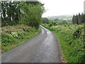
1
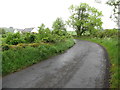
Cottages near the northern end of Oldbridge Road
Image: © Eric Jones
Taken: 7 Jun 2017
0.05 miles
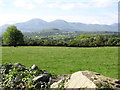
2

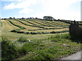
Cropland and woodland in the Leitrim Valley
The village of Annsborough (left) and the town of Castlewellan (right) can be seen beyond the woodland. Slieve Donard and its acolytes form the background.
Image: © Eric Jones
Taken: 7 Jun 2017
0.11 miles
3
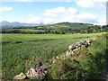
Cropland between Wood Road and the Leitrim Valley
Beyond the valley are the hills of Curlets Mountain and Slievenaslat in the Castlewellan Forest Park. The high mountains in the background are The Mournes.
Image: © Eric Jones
Taken: 7 Jun 2017
0.13 miles
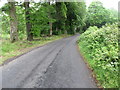
4
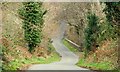
The Oldbridge Road near Castlewellan (2)
See Image The road, in this square, as it approaches the Old Bridge across the Leitrim River.
Image: © Albert Bridge
Taken: 1 Apr 2009
0.16 miles
6
Oldbridge Road on the north side of the bridge over the Leitrim River
Image: © Eric Jones
Taken: 7 Jun 2017
0.19 miles
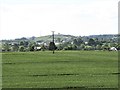
7
Farmland on the west side of McKays Road
This is an area of heavy clays favouring mainly pastoral farming with arable land confined to the better drained drumlin slopes. The background is dominated by the High Mournes.
Image: © Eric Jones
Taken: 19 May 2016
0.20 miles
8
View across cropland towards a classic shaped drumlin
The drumlin is on the other side of the Ardnabannon Road.
Image: © Eric Jones
Taken: 7 Jun 2017
0.21 miles
9
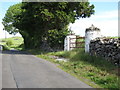
Pillared gateway at the northern end of McKays Road
Such pillared field gates are becoming an endangered species as entrances are widened for the passage of farm machinery. Even along this road, there are instances where only one of the two pillars have survived.
Image: © Eric Jones
Taken: 19 May 2016
0.23 miles