IMAGES TAKEN NEAR TO
Drumee Cottages, CASTLEWELLAN, BT31 9HA
Introduction
This page details the photographs taken nearby to Drumee Cottages, BT31 9HA by members of the Geograph project.
The Geograph project started in 2005 with the aim of publishing, organising and preserving representative images for every square kilometre of Great Britain, Ireland and the Isle of Man.

There are currently over 7.5m images from over14,400 individuals and you can help contribute to the project by visiting https://www.geograph.org.uk
Image Map
Images are licensed for reuse under creativecommons.org/licenses/by-sa/2.0
Notes
- Clicking on the map will re-center to the selected point.
- The higher the marker number, the further away the image location is from the centre of the postcode.
Image Listing (45 Images Found)
Images are licensed for reuse under creativecommons.org/licenses/by-sa/2.0
Image
Details
Distance
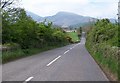
1
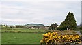
View northwards towards Dundrinne Road
Bunkers Hill above Castlewellan can be seen in the background.
Image: © Eric Jones
Taken: 13 May 2010
0.02 miles
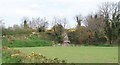
2
Houses on Dundrinne Road, Maghera
The image was taken from the Ulster Way.
Image: © Eric Jones
Taken: 15 Aug 2020
0.02 miles
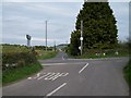
3
The Dundrinne Cross Roads on the B180 at Maghera
Here, the Dundrinne Road from the north and Carrigs Road from the south meet the east-west Carnacaville Road (B180). The image was taken from the Ulster Way long distance path.
Image: © Eric Jones
Taken: 15 Aug 2020
0.08 miles
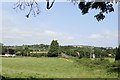
5
Carnacaville Road west of Maghera Bridge
This road links Maghera with the A50 (Newcastle-Castlewellan Road). Beyond the crossroads stands Maghera's St Joseph's Primary School.
Image: © Eric Jones
Taken: 13 May 2010
0.08 miles
7
Crossroads west of Maghera village
This is the view north westwards from Carrigs Road across Carnacaville Road towards Dundrine Road.
Image: © Eric Jones
Taken: 13 May 2010
0.09 miles
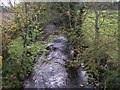
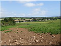
9
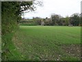
View north across cropland to the Maghera Bridge
The bridge spans the Carrig River.
Image: © Eric Jones
Taken: 13 May 2010
0.10 miles
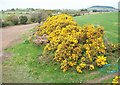
10
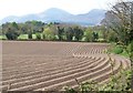
View SSW towards Carrigs River and the Mournes from Ballyginny
The line of trees at the end of the potato field marks the position of the Carrigs River.
Image: © Eric Jones
Taken: 13 May 2010
0.11 miles