IMAGES TAKEN NEAR TO
BT31 9FL
Introduction
This page details the photographs taken nearby to BT31 9FL by members of the Geograph project.
The Geograph project started in 2005 with the aim of publishing, organising and preserving representative images for every square kilometre of Great Britain, Ireland and the Isle of Man.

There are currently over 7.5m images from over14,400 individuals and you can help contribute to the project by visiting https://www.geograph.org.uk
Image Map
Images are licensed for reuse under creativecommons.org/licenses/by-sa/2.0
Notes
- Clicking on the map will re-center to the selected point.
- The higher the marker number, the further away the image location is from the centre of the postcode.
Image Listing (200 Images Found)
Images are licensed for reuse under creativecommons.org/licenses/by-sa/2.0
Image
Details
Distance
3
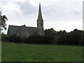
St Paul's Church, Castlewellan, viewed from Mill Hill
Image: © Eric Jones
Taken: 8 Nov 2010
0.09 miles
4
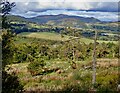
Northern slope of Bunkers Hill with the Slieve Croob range in the background
Image: © Eric Jones
Taken: 28 Sep 2022
0.11 miles
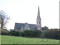
5
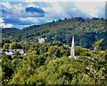
The steeple of St Paul's CoI viewed from Bunkers Hill
In the background is Castlewellan Castle, the former home of the Annesleys surrounded by its parkland and forests. St Paul's was the place of worship of the Anglican Annesleys and most of their senior retainers.
Image: © Eric Jones
Taken: 28 Sep 2022
0.11 miles
6
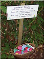
A lovely gesture of kindness at Bunkers Hill Forest Park
Image: © Eric Jones
Taken: 28 Sep 2022
0.12 miles
7
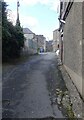
Ascending Mary Street, Castlewellan
This is narrow back lane behind the Upper Square.
Image: © Eric Jones
Taken: 28 Sep 2022
0.13 miles
9
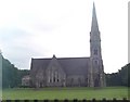
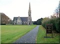
St Paul's Church of Ireland, Castlewellan
This church was built as a chapel of ease in the 1850s to serve the western part of Kilmegan parish and was paid for by the Annesley family. It became a parish church only in 1977. It is located on Mill Hill.
Image: © Eric Jones
Taken: 20 Aug 2009
0.14 miles
10
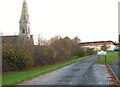
The Castlewellan Primary School
This non-denominational state school is located next to St Peter's CoI church. It has around 80 pupils.
http://www.castlewellanprimary.org.uk/homedir/prospectus.htm
Image: © Eric Jones
Taken: 8 Nov 2010
0.14 miles